Fontecchio geodata
Fontecchio (Abruzzo) is a seat of a third-order administrative division; located in Italy in Europe/Rome (GMT+2) time zone. With population of 323 people, there are 10580 cities with bigger population in this country. Compared to other cities in Italy, 68.4% of cities are located further ↑North; 74.7% of cities are located further ←West and 87.5% of cities have lower elevation than Fontecchio. Note1


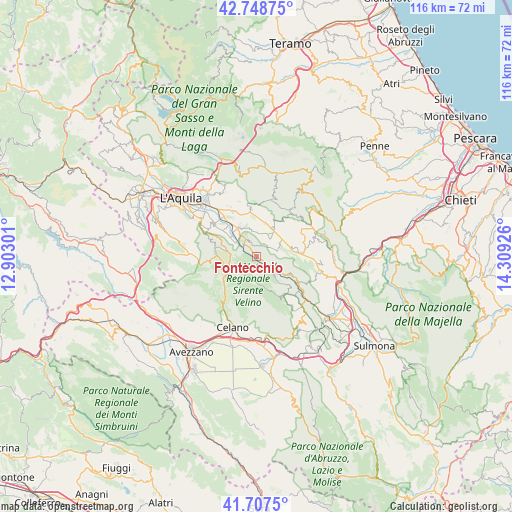
Fontecchio GPS coordinates[2]
42° 13' 48.972" North, 13° 36' 22.068" East
| Map corner | latitude | longitude |
|---|---|---|
| Upper-left | 42.74875°, | 12.90301° |
| Center: | 42.23027°, | 13.60613° |
| Lower-right: | 41.7075°, | 14.30926° |
| Map W x H: | 115.8×115.8 km | = 72×72mi |
| max Lat: | 47.04031° ⇑68.4% North |
| Fontecchio: | 42.23027° |
| min Lat: | ⇓31.6% South 35.50142° |
| min Long | Fontecchio | max Long |
| 6.69888° | 13.60613° | 18.48682° |
| W 74.7%⇐ | ⇒25.3% E |
Elevation
Elevation of Fontecchio is 664 m = 2178 ft, and this is 357.3 m = 1172 ft above average elevation for this country.
| Max E: |
2085 m = 6841 ft | 12.5% |
| Fontecchio | 664 m 2178 ft | |
| Avg. | 306.7 m = 1006 ft | |
Min E: |
-4 m = -13 ft | 87.5% |
See also: Italy elevation on elevation.city.
Geographical zone
Fontecchio is located in North temperate zone (between Tropic of Cancer and the Arctic Circle). Distance of this Northern Tropic circle is 2089.6 km =1298.4 mi to South.| Distance of | km | miles | from Fontecchio |
|---|---|---|---|
| North Pole | 5311.5 | 3300.4 | to North |
| Arctic Circle | 2705.6 | 1681.2 | to North |
| Tropic Cancer | 2089.6 | 1298.4 | to South |
| Equator | 4695.6 | 2917.7 | to South |


Nearby cities:
15 places around Fontecchio: (largest is in red/bold)
• Acciano
11 km =6.8 mi,  122°
122°
• Barisciano
10.6 km =6.6 mi,  352°
352°
• Caporciano
6 km =3.7 mi,  68°
68°
• Carapelle Calvisio
10.1 km =6.3 mi,  40°
40°
• Navelli
10.2 km =6.3 mi,  85°
85°
• Prata d'Ansidonia
5.3 km =3.3 mi,  1°
1°
• Rocca di Cambio
9.7 km =6 mi,  274°
274°
• Rocca di Mezzo
7.8 km =4.8 mi,  248°
248°
• San Demetrio Ne' Vestini
7.8 km =4.8 mi,  327°
327°
• San Pio delle Camere
7.3 km =4.5 mi,  34°
34°
• Sant'Eusanio Forconese
9.4 km =5.8 mi,  314°
314°
• Secinaro
10.8 km =6.7 mi,  144°
144°
• Tione degli Abruzzi
3.8 km =2.4 mi, 140°
• Vallecupa
3.7 km =2.3 mi,  315°
315°
• Villa Sant'Angelo
7.2 km =4.5 mi, 308°
Sources, notices
• [Note1] Compared only with cities in Italy existing in our database
• [Src1] Map data: © OpenStreetMap contributors (CC-BY-SA)
• [Src2] Other city data from geonames.org with taken over terms of usage.
• [Src3] Geographical zone / Annual Mean Temperature by Robert A. Rohde @ Wikipedia
