Carapelle Calvisio geodata
Carapelle Calvisio (Abruzzo) is a seat of a third-order administrative division; located in Italy in Europe/Rome (GMT+2) time zone. With population of 95 people, there are 11458 cities with bigger population in this country. Compared to other cities in Italy, 67.7% of cities are located further ↑North; 75.5% of cities are located further ←West and 94.2% of cities have lower elevation than Carapelle Calvisio. Note1
Administrative division(s):
- Level 1: Abruzzo
- Level 2: Provincia dell' Aquila
- Level 3: Carapelle Calvisio


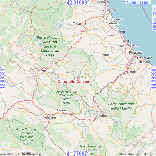
Carapelle Calvisio GPS coordinates[2]
42° 17' 56.688" North, 13° 41' 11.148" East
| Map corner | latitude | longitude |
|---|---|---|
| Upper-left | 42.81699°, | 12.98331° |
| Center: | 42.29908°, | 13.68643° |
| Lower-right: | 41.77687°, | 14.38956° |
| Map W x H: | 115.7×115.6 km | = 71.9×71.8mi |
| max Lat: | 47.04031° ⇑67.7% North |
| Carapelle Calvisio: | 42.29908° |
| min Lat: | ⇓32.3% South 35.50142° |
| min Long | Carapelle Calvi | max Long |
| 6.69888° | 13.68643° | 18.48682° |
| W 75.5%⇐ | ⇒24.5% E |
Elevation
Elevation of Carapelle Calvisio is 845 m = 2772 ft, and this is 538.3 m = 1766 ft above average elevation for this country.
| Max E: |
2085 m = 6841 ft | 5.8% |
| Carapelle Calvisio | 845 m 2772 ft | |
| Avg. | 306.7 m = 1006 ft | |
Min E: |
-4 m = -13 ft | 94.2% |
See also: Italy elevation on elevation.city.
Geographical zone
Carapelle Calvisio is located in North temperate zone (between Tropic of Cancer and the Arctic Circle). Distance of this Northern Tropic circle is 2097.3 km =1303.2 mi to South.| Distance of | km | miles | from Carapelle Calvisio |
|---|---|---|---|
| North Pole | 5303.8 | 3295.6 | to North |
| Arctic Circle | 2698 | 1676.5 | to North |
| Tropic Cancer | 2097.3 | 1303.2 | to South |
| Equator | 4703.2 | 2922.4 | to South |


Nearby cities:
15 places around Carapelle Calvisio: (largest is in red/bold)
• Barisciano
8.4 km =5.2 mi,  289°
289°
• Calascio
3.1 km =1.9 mi,  16°
16°
• Capestrano
7.5 km =4.7 mi,  117°
117°
• Caporciano
5.5 km =3.4 mi,  190°
190°
• Castel del Monte
8.1 km =5 mi, 23°
• Castelvecchio Calvisio
1.4 km =0.9 mi,  2°
2°
• Fontecchio
10.1 km =6.3 mi,  220°
220°
• Navelli
7.7 km =4.8 mi,  152°
152°
• Ofena
6.6 km =4.1 mi,  63°
63°
• Prata d'Ansidonia
6.8 km =4.2 mi,  249°
249°
• San Demetrio Ne' Vestini
10.8 km =6.7 mi,  264°
264°
• San Pio delle Camere
3 km =1.9 mi,  236°
236°
• Santo Stefano di Sessanio
6 km =3.7 mi,  325°
325°
• Vallecupa
10.5 km =6.5 mi, 241°
• Villa Santa Lucia degli Abruzzi
8.4 km =5.2 mi, 63°
Sources, notices
• [Note1] Compared only with cities in Italy existing in our database
• [Src1] Map data: © OpenStreetMap contributors (CC-BY-SA)
• [Src2] Other city data from geonames.org with taken over terms of usage.
• [Src3] Geographical zone / Annual Mean Temperature by Robert A. Rohde @ Wikipedia
