Follonica geodata
Follonica (Tuscany) is a seat of a third-order administrative division; located in Italy in Europe/Rome (GMT+2) time zone. With population of 21,163 people, there are 414 cities with bigger population in this country. Compared to other cities in Italy, 63.8% of cities are located further ↑North; 60.1% of cities are located further →East and 93.6% of cities have higher elevation than Follonica. Note1


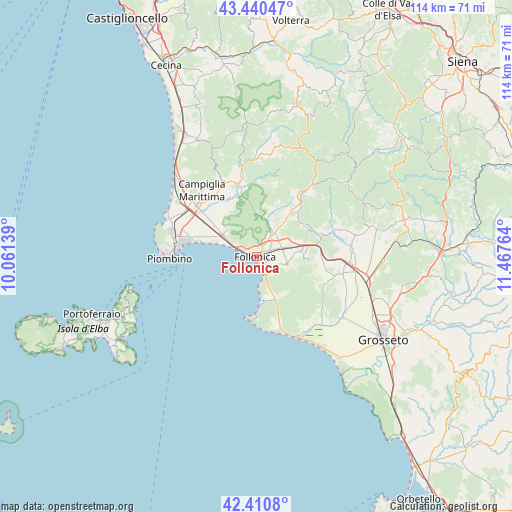
Follonica GPS coordinates[2]
42° 55' 40.044" North, 10° 45' 52.236" East
| Map corner | latitude | longitude |
|---|---|---|
| Upper-left | 43.44047°, | 10.06139° |
| Center: | 42.92779°, | 10.76451° |
| Lower-right: | 42.4108°, | 11.46764° |
| Map W x H: | 114.5×114.5 km | = 71.1×71.1mi |
| max Lat: | 47.04031° ⇑63.8% North |
| Follonica: | 42.92779° |
| min Lat: | ⇓36.2% South 35.50142° |
| min Long | Follonica | max Long |
| 6.69888° | 10.76451° | 18.48682° |
| W 39.9%⇐ | ⇒60.1% E |
Elevation
Elevation of Follonica is 11 m = 36 ft, and this is 295.7 m = 970 ft below average elevation for this country.
| Max E: |
2085 m = 6841 ft | 93.6% |
| Avg. | 306.7 m = 1006 ft | |
| Follonica | 11 m = 36 ft | |
Min E: |
-4 m = -13 ft | 6.4% |
See also: Italy elevation on elevation.city.
Geographical zone
Follonica is located in North temperate zone (between Tropic of Cancer and the Arctic Circle). Distance of this Northern Tropic circle is 2167.2 km =1346.6 mi to South.| Distance of | km | miles | from Follonica |
|---|---|---|---|
| North Pole | 5233.9 | 3252.2 | to North |
| Arctic Circle | 2628.1 | 1633 | to North |
| Tropic Cancer | 2167.2 | 1346.6 | to South |
| Equator | 4773.1 | 2965.9 | to South |


Nearby cities:
15 places around Follonica: (largest is in red/bold)
• Caldana
13.6 km =8.5 mi,  106°
106°
• Campiglia Marittima
19.1 km =11.9 mi,  320°
320°
• Castiglione della Pescaia
20 km =12.4 mi,  152°
152°
• Filare-Boschetto-Miniera
10.9 km =6.8 mi,  90°
90°
• Gavorrano
11.6 km =7.2 mi, 91°
• Massa Marittima
16.9 km =10.5 mi,  38°
38°
• Piombino
19.4 km =12.1 mi,  269°
269°
• Portiglioni
5.4 km =3.4 mi,  167°
167°
• Ribolla
22.6 km =14 mi,  77°
77°
• Sassetta
24.4 km =15.2 mi,  336°
336°
• Scarlino
7.4 km =4.6 mi, 107°
• Scarlino Scalo
6.1 km =3.8 mi, 77°
• Suvereto
18 km =11.2 mi, 336°
• Venturina
17.4 km =10.8 mi,  310°
310°
• Vignale Riotorto
8.7 km =5.4 mi, 311°
Sources, notices
• [Note1] Compared only with cities in Italy existing in our database
• [Src1] Map data: © OpenStreetMap contributors (CC-BY-SA)
• [Src2] Other city data from geonames.org with taken over terms of usage.
• [Src3] Geographical zone / Annual Mean Temperature by Robert A. Rohde @ Wikipedia
