Ribolla geodata
Ribolla (Tuscany) is a populated place; located in Italy in Europe/Rome (GMT+2) time zone. With population of 2,438 people, there are 3601 cities with bigger population in this country. Compared to other cities in Italy, 63.6% of cities are located further ↑North; 56.8% of cities are located further →East and 77.9% of cities have higher elevation than Ribolla. Note1


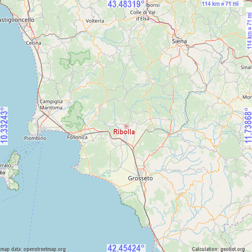
Ribolla GPS coordinates[2]
42° 58' 15.132" North, 11° 2' 7.98" East
| Map corner | latitude | longitude |
|---|---|---|
| Upper-left | 43.48319°, | 10.33243° |
| Center: | 42.97087°, | 11.03555° |
| Lower-right: | 42.45424°, | 11.73868° |
| Map W x H: | 114.4×114.4 km | = 71.1×71.1mi |
| max Lat: | 47.04031° ⇑63.6% North |
| Ribolla: | 42.97087° |
| min Lat: | ⇓36.4% South 35.50142° |
| min Long | Ribolla | max Long |
| 6.69888° | 11.03555° | 18.48682° |
| W 43.2%⇐ | ⇒56.8% E |
Elevation
Elevation of Ribolla is 60 m = 197 ft, and this is 246.7 m = 809 ft below average elevation for this country.
| Max E: |
2085 m = 6841 ft | 77.9% |
| Avg. | 306.7 m = 1006 ft | |
| Ribolla | 60 m = 197 ft | |
Min E: |
-4 m = -13 ft | 22.1% |
See also: Italy elevation on elevation.city.
Geographical zone
Ribolla is located in North temperate zone (between Tropic of Cancer and the Arctic Circle). Distance of this Northern Tropic circle is 2172 km =1349.6 mi to South.| Distance of | km | miles | from Ribolla |
|---|---|---|---|
| North Pole | 5229.1 | 3249.2 | to North |
| Arctic Circle | 2623.3 | 1630 | to North |
| Tropic Cancer | 2172 | 1349.6 | to South |
| Equator | 4777.9 | 2968.8 | to South |


Nearby cities:
15 places around Ribolla: (largest is in red/bold)
• Batignano
15.8 km =9.8 mi,  137°
137°
• Braccagni
11.3 km =7 mi,  164°
164°
• Caldana
12.4 km =7.7 mi,  226°
226°
• Filare-Boschetto-Miniera
12.2 km =7.6 mi,  245°
245°
• Gavorrano
11.6 km =7.2 mi,  244°
244°
• Massa Marittima
14.4 km =8.9 mi,  306°
306°
• Montieri
17.9 km =11.1 mi,  355°
355°
• Paganico
19.5 km =12.1 mi,  101°
101°
• Prata
13.1 km =8.1 mi,  341°
341°
• Roccastrada
11.5 km =7.1 mi,  68°
68°
• Roccatederighi
7.4 km =4.6 mi,  30°
30°
• Sassofortino
8.7 km =5.4 mi,  45°
45°
• Scarlino
16.5 km =10.3 mi, 244°
• Scarlino Scalo
16.5 km =10.3 mi,  257°
257°
• Sticciano Scalo
8.4 km =5.2 mi,  126°
126°
Sources, notices
• [Note1] Compared only with cities in Italy existing in our database
• [Src1] Map data: © OpenStreetMap contributors (CC-BY-SA)
• [Src2] Other city data from geonames.org with taken over terms of usage.
• [Src3] Geographical zone / Annual Mean Temperature by Robert A. Rohde @ Wikipedia
