Gavorrano geodata
Gavorrano (Tuscany) is a seat of a third-order administrative division; located in Italy in Europe/Rome (GMT+2) time zone. With population of 742 people, there are 8007 cities with bigger population in this country. Compared to other cities in Italy, 63.8% of cities are located further ↑North; 58.4% of cities are located further →East and 54.4% of cities have lower elevation than Gavorrano. Note1


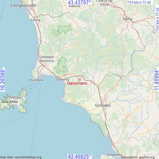
Gavorrano GPS coordinates[2]
42° 55' 30.936" North, 10° 54' 24.516" East
| Map corner | latitude | longitude |
|---|---|---|
| Upper-left | 43.43797°, | 10.20369° |
| Center: | 42.92526°, | 10.90681° |
| Lower-right: | 42.40825°, | 11.60994° |
| Map W x H: | 114.5×114.5 km | = 71.1×71.1mi |
| max Lat: | 47.04031° ⇑63.8% North |
| Gavorrano: | 42.92526° |
| min Lat: | ⇓36.2% South 35.50142° |
| min Long | Gavorrano | max Long |
| 6.69888° | 10.90681° | 18.48682° |
| W 41.6%⇐ | ⇒58.4% E |
Elevation
Elevation of Gavorrano is 262 m = 860 ft, and this is 44.7 m = 147 ft below average elevation for this country.
| Max E: |
2085 m = 6841 ft | 45.6% |
| Avg. | 306.7 m = 1006 ft | |
| Gavorrano | 262 m = 860 ft | |
Min E: |
-4 m = -13 ft | 54.4% |
See also: Italy elevation on elevation.city.
Geographical zone
Gavorrano is located in North temperate zone (between Tropic of Cancer and the Arctic Circle). Distance of this Northern Tropic circle is 2166.9 km =1346.4 mi to South.| Distance of | km | miles | from Gavorrano |
|---|---|---|---|
| North Pole | 5234.2 | 3252.4 | to North |
| Arctic Circle | 2628.3 | 1633.1 | to North |
| Tropic Cancer | 2166.9 | 1346.4 | to South |
| Equator | 4772.8 | 2965.7 | to South |


Nearby cities:
15 places around Gavorrano: (largest is in red/bold)
• Braccagni
14.7 km =9.1 mi,  113°
113°
• Caldana
3.8 km =2.4 mi,  156°
156°
• Castiglione della Pescaia
17.6 km =10.9 mi,  187°
187°
• Filare-Boschetto-Miniera
0.7 km =0.4 mi,  278°
278°
• Follonica
11.6 km =7.2 mi,  271°
271°
• Massa Marittima
13.7 km =8.5 mi,  355°
355°
• Portiglioni
11.5 km =7.1 mi,  244°
244°
• Prata
18.7 km =11.6 mi,  20°
20°
• Ribolla
11.6 km =7.2 mi,  64°
64°
• Roccatederighi
18.2 km =11.3 mi,  51°
51°
• Sassofortino
20 km =12.4 mi, 56°
• Scarlino
4.9 km =3 mi,  246°
246°
• Scarlino Scalo
5.9 km =3.7 mi,  286°
286°
• Sticciano Scalo
17.2 km =10.7 mi,  89°
89°
• Vignale Riotorto
19.1 km =11.9 mi, 288°
Sources, notices
• [Note1] Compared only with cities in Italy existing in our database
• [Src1] Map data: © OpenStreetMap contributors (CC-BY-SA)
• [Src2] Other city data from geonames.org with taken over terms of usage.
• [Src3] Geographical zone / Annual Mean Temperature by Robert A. Rohde @ Wikipedia
