Fognano geodata
Fognano (Emilia-Romagna) is a populated place; located in Italy in Europe/Rome (GMT+2) time zone. With population of 1,400 people, there are 5358 cities with bigger population in this country. Compared to other cities in Italy, 52.7% of cities are located further ↑North; 52.3% of cities are located further ←West and 64.9% of cities have higher elevation than Fognano. Note1
Administrative division(s):
- Level 1: Emilia-Romagna
- Level 2: Provincia di Ravenna
- Level 3: Brisighella


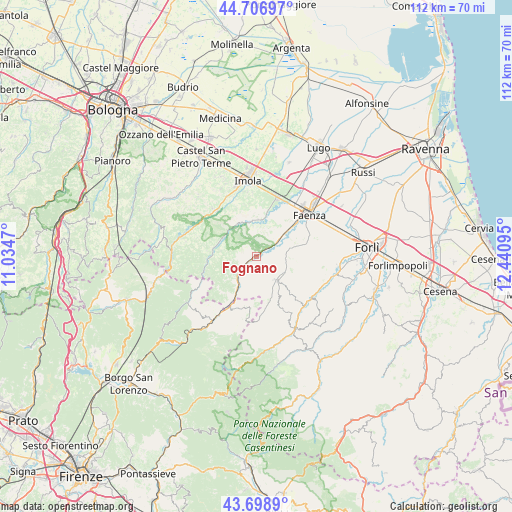
Fognano GPS coordinates[2]
44° 12' 18.324" North, 11° 44' 16.152" East
| Map corner | latitude | longitude |
|---|---|---|
| Upper-left | 44.70697°, | 11.0347° |
| Center: | 44.20509°, | 11.73782° |
| Lower-right: | 43.6989°, | 12.44095° |
| Map W x H: | 112.1×112.1 km | = 69.7×69.7mi |
| max Lat: | 47.04031° ⇑52.7% North |
| Fognano: | 44.20509° |
| min Lat: | ⇓47.3% South 35.50142° |
| min Long | Fognano | max Long |
| 6.69888° | 11.73782° | 18.48682° |
| W 52.3%⇐ | ⇒47.7% E |
Elevation
Elevation of Fognano is 128 m = 420 ft, and this is 178.7 m = 586 ft below average elevation for this country.
| Max E: |
2085 m = 6841 ft | 64.9% |
| Avg. | 306.7 m = 1006 ft | |
| Fognano | 128 m = 420 ft | |
Min E: |
-4 m = -13 ft | 35.1% |
See also: Italy elevation on elevation.city.
Geographical zone
Fognano is located in North temperate zone (between Tropic of Cancer and the Arctic Circle). Distance of this Northern Tropic circle is 2309.2 km =1434.9 mi to South.| Distance of | km | miles | from Fognano |
|---|---|---|---|
| North Pole | 5091.9 | 3164 | to North |
| Arctic Circle | 2486 | 1544.7 | to North |
| Tropic Cancer | 2309.2 | 1434.9 | to South |
| Equator | 4915.1 | 3054.1 | to South |


Nearby cities:
15 places around Fognano: (largest is in red/bold)
• Borgo Tossignano
14.2 km =8.8 mi,  307°
307°
• Brisighella
3.4 km =2.1 mi,  56°
56°
• Casalfiumanese
13.6 km =8.5 mi,  318°
318°
• Casola Valsenio
9.3 km =5.8 mi,  283°
283°
• Castel Bolognese
13.7 km =8.5 mi,  20°
20°
• Castrocaro Terme
17.2 km =10.7 mi,  101°
101°
• Dovadola
15.1 km =9.4 mi,  127°
127°
• Faenza
14.7 km =9.1 mi,  50°
50°
• Fontanelice
15.5 km =9.6 mi,  292°
292°
• Imola
17.2 km =10.7 mi,  353°
353°
• Marradi
17.8 km =11.1 mi,  214°
214°
• Modigliana
6.7 km =4.2 mi,  139°
139°
• Ponticelli
14.5 km =9 mi,  332°
332°
• Riolo Terme
7.9 km =4.9 mi, 353°
• Tredozio
14 km =8.7 mi,  178°
178°
Sources, notices
• [Note1] Compared only with cities in Italy existing in our database
• [Src1] Map data: © OpenStreetMap contributors (CC-BY-SA)
• [Src2] Other city data from geonames.org with taken over terms of usage.
• [Src3] Geographical zone / Annual Mean Temperature by Robert A. Rohde @ Wikipedia
