Imola geodata
Imola (Emilia-Romagna) is a seat of a third-order administrative division; located in Italy in Europe/Rome (GMT+2) time zone. With population of 52,981 people, there are 106 cities with bigger population in this country. Compared to other cities in Italy, 51.1% of cities are located further ↑North; 52% of cities are located further ←West and 80.5% of cities have higher elevation than Imola. Note1


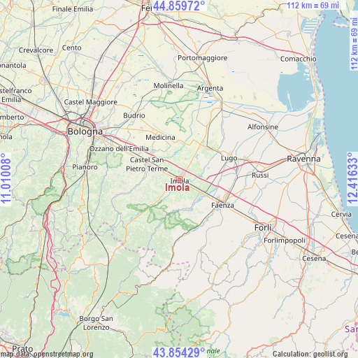
Imola GPS coordinates[2]
44° 21' 32.976" North, 11° 42' 47.52" East
| Map corner | latitude | longitude |
|---|---|---|
| Upper-left | 44.85972°, | 11.01008° |
| Center: | 44.35916°, | 11.7132° |
| Lower-right: | 43.85429°, | 12.41633° |
| Map W x H: | 111.8×111.8 km | = 69.5×69.5mi |
| max Lat: | 47.04031° ⇑51.1% North |
| Imola: | 44.35916° |
| min Lat: | ⇓48.9% South 35.50142° |
| min Long | Imola | max Long |
| 6.69888° | 11.7132° | 18.48682° |
| W 52%⇐ | ⇒48% E |
Elevation
Elevation of Imola is 47 m = 154 ft, and this is 259.7 m = 852 ft below average elevation for this country.
| Max E: |
2085 m = 6841 ft | 80.5% |
| Avg. | 306.7 m = 1006 ft | |
| Imola | 47 m = 154 ft | |
Min E: |
-4 m = -13 ft | 19.5% |
See also: Imola elevation on elevation.city.
Geographical zone
Imola is located in North temperate zone (between Tropic of Cancer and the Arctic Circle). Distance of this Northern Tropic circle is 2326.4 km =1445.6 mi to South.| Distance of | km | miles | from Imola |
|---|---|---|---|
| North Pole | 5074.8 | 3153.3 | to North |
| Arctic Circle | 2468.9 | 1534.1 | to North |
| Tropic Cancer | 2326.4 | 1445.6 | to South |
| Equator | 4932.3 | 3064.8 | to South |


Nearby cities:
15 places around Imola: (largest is in red/bold)
• Bagnara di Romagna
9.7 km =6 mi,  69°
69°
• Bubano
8.2 km =5.1 mi,  42°
42°
• Casalfiumanese
9.9 km =6.2 mi,  225°
225°
• Castel Bolognese
8.1 km =5 mi,  122°
122°
• Castel Guelfo di Bologna
8.6 km =5.3 mi,  339°
339°
• Castel San Pietro Terme
11.1 km =6.9 mi,  293°
293°
• Dozza
6.2 km =3.9 mi,  272°
272°
• Mordano
8.6 km =5.3 mi,  60°
60°
• Ponticelli
6.4 km =4 mi, 228°
• Riolo Terme
9.3 km =5.8 mi,  173°
173°
• San Prospero
5 km =3.1 mi,  83°
83°
• Sasso Morelli
6.6 km =4.1 mi,  17°
17°
• Sesto Imolese
11.2 km =7 mi,  6°
6°
• Solarolo
10.6 km =6.6 mi,  90°
90°
• Toscanella
6.4 km =4 mi, 293°
Sources, notices
• [Note1] Compared only with cities in Italy existing in our database
• [Src1] Map data: © OpenStreetMap contributors (CC-BY-SA)
• [Src2] Other city data from geonames.org with taken over terms of usage.
• [Src3] Geographical zone / Annual Mean Temperature by Robert A. Rohde @ Wikipedia
