Faenza geodata
Faenza (Emilia-Romagna) is a seat of a third-order administrative division; located in Italy in Europe/Rome (GMT+2) time zone. With population of 41,714 people, there are 170 cities with bigger population in this country. Compared to other cities in Italy, 52% of cities are located further ↑North; 54.2% of cities are located further ←West and 82.2% of cities have higher elevation than Faenza. Note1


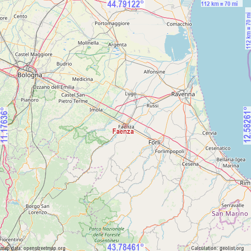
Faenza GPS coordinates[2]
44° 17' 24.252" North, 11° 52' 46.128" East
| Map corner | latitude | longitude |
|---|---|---|
| Upper-left | 44.79122°, | 11.17636° |
| Center: | 44.29007°, | 11.87948° |
| Lower-right: | 43.78461°, | 12.58261° |
| Map W x H: | 111.9×111.9 km | = 69.5×69.5mi |
| max Lat: | 47.04031° ⇑52% North |
| Faenza: | 44.29007° |
| min Lat: | ⇓48% South 35.50142° |
| min Long | Faenza | max Long |
| 6.69888° | 11.87948° | 18.48682° |
| W 54.2%⇐ | ⇒45.8% E |
Elevation
Elevation of Faenza is 41 m = 135 ft, and this is 265.7 m = 872 ft below average elevation for this country.
| Max E: |
2085 m = 6841 ft | 82.2% |
| Avg. | 306.7 m = 1006 ft | |
| Faenza | 41 m = 135 ft | |
Min E: |
-4 m = -13 ft | 17.8% |
See also: Faenza elevation on elevation.city.
Geographical zone
Faenza is located in North temperate zone (between Tropic of Cancer and the Arctic Circle). Distance of this Northern Tropic circle is 2318.7 km =1440.8 mi to South.| Distance of | km | miles | from Faenza |
|---|---|---|---|
| North Pole | 5082.5 | 3158.1 | to North |
| Arctic Circle | 2476.6 | 1538.9 | to North |
| Tropic Cancer | 2318.7 | 1440.8 | to South |
| Equator | 4924.6 | 3060 | to South |


Nearby cities:
15 places around Faenza: (largest is in red/bold)
• Bagnara di Romagna
11.8 km =7.3 mi,  339°
339°
• Barbiano
11.1 km =6.9 mi,  2°
2°
• Brisighella
11.3 km =7 mi,  228°
228°
• Castel Bolognese
7.2 km =4.5 mi,  297°
297°
• Castrocaro Terme
13.9 km =8.6 mi,  156°
156°
• Castrocaro Terme e Terra del Sole
13.2 km =8.2 mi,  150°
150°
• Cotignola
11.6 km =7.2 mi,  23°
23°
• Granarolo
8.8 km =5.5 mi,  29°
29°
• Mordano
13.2 km =8.2 mi,  334°
334°
• Reda
7.2 km =4.5 mi,  79°
79°
• Riolo Terme
12.2 km =7.6 mi,  262°
262°
• Roncadello
13.5 km =8.4 mi,  101°
101°
• San Prospero
11.7 km =7.3 mi,  315°
315°
• Solarolo
8.1 km =5 mi, 341°
• Villanova
9.3 km =5.8 mi,  120°
120°
Sources, notices
• [Note1] Compared only with cities in Italy existing in our database
• [Src1] Map data: © OpenStreetMap contributors (CC-BY-SA)
• [Src2] Other city data from geonames.org with taken over terms of usage.
• [Src3] Geographical zone / Annual Mean Temperature by Robert A. Rohde @ Wikipedia
