Feletto Umberto geodata
Feletto Umberto (Friuli Venezia Giulia) is a seat of a third-order administrative division; located in Italy in Europe/Rome (GMT+2) time zone. In our database, there are 11707 cities with bigger population. Compared to other cities in Italy, 94.1% of cities are located further ↓South; 70.6% of cities are located further ←West and 65.3% of cities have higher elevation than Feletto Umberto. Note1
Administrative division(s):
- Level 1: Friuli Venezia Giulia
- Level 2: Provincia di Udine
- Level 3: Tavagnacco


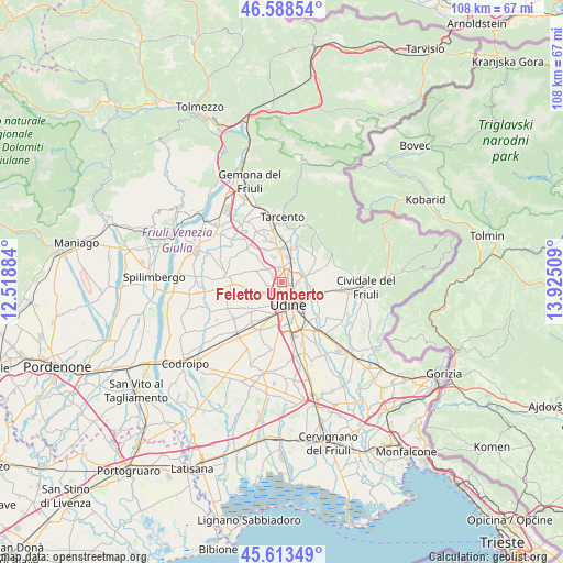
Feletto Umberto GPS coordinates[2]
46° 6' 11.412" North, 13° 13' 19.056" East
| Map corner | latitude | longitude |
|---|---|---|
| Upper-left | 46.58854°, | 12.51884° |
| Center: | 46.10317°, | 13.22196° |
| Lower-right: | 45.61349°, | 13.92509° |
| Map W x H: | 108.4×108.4 km | = 67.4×67.4mi |
| max Lat: | 47.04031° ⇑5.9% North |
| Feletto Umberto: | 46.10317° |
| min Lat: | ⇓94.1% South 35.50142° |
| min Long | Feletto Umberto | max Long |
| 6.69888° | 13.22196° | 18.48682° |
| W 70.6%⇐ | ⇒29.4% E |
Elevation
Elevation of Feletto Umberto is 126 m = 413 ft, and this is 180.7 m = 593 ft below average elevation for this country.
| Max E: |
2085 m = 6841 ft | 65.3% |
| Avg. | 306.7 m = 1006 ft | |
| Feletto Umberto | 126 m = 413 ft | |
Min E: |
-4 m = -13 ft | 34.7% |
See also: Italy elevation on elevation.city.
Geographical zone
Feletto Umberto is located in North temperate zone (between Tropic of Cancer and the Arctic Circle). Distance of this North polar circle is 2275 km =1413.6 mi to North.| Distance of | km | miles | from Feletto Umberto |
|---|---|---|---|
| North Pole | 4880.9 | 3032.8 | to North |
| Arctic Circle | 2275 | 1413.6 | to North |
| Tropic Cancer | 2520.3 | 1566 | to South |
| Equator | 5126.2 | 3185.3 | to South |


Nearby cities:
15 places around Feletto Umberto: (largest is in red/bold)
• Brazzacco
5.2 km =3.2 mi,  292°
292°
• Casanova
4.2 km =2.6 mi,  224°
224°
• Colugna
2 km =1.2 mi,  227°
227°
• Martignacco
6.4 km =4 mi,  260°
260°
• Nogaredo di Prato
7.4 km =4.6 mi,  245°
245°
• Pagnacco
3.2 km =2 mi, 293°
• Pasian di Prato
6.8 km =4.2 mi,  202°
202°
• Passons
4.6 km =2.9 mi,  213°
213°
• Povoletto
5.6 km =3.5 mi,  75°
75°
• Primulacco
6.2 km =3.9 mi,  42°
42°
• Reana del Roiale
3.8 km =2.4 mi,  1°
1°
• Reana del Rojale
4.8 km =3 mi,  23°
23°
• Tavagnacco
0.7 km =0.4 mi, 3°
• Tricesimo
6.4 km =4 mi,  355°
355°
• Udine
3.9 km =2.4 mi,  162°
162°
Sources, notices
• [Note1] Compared only with cities in Italy existing in our database
• [Src1] Map data: © OpenStreetMap contributors (CC-BY-SA)
• [Src2] Other city data from geonames.org with taken over terms of usage.
• [Src3] Geographical zone / Annual Mean Temperature by Robert A. Rohde @ Wikipedia
