Passons geodata
Passons (Friuli Venezia Giulia) is a populated place; located in Italy in Europe/Rome (GMT+2) time zone. With population of 2,649 people, there are 3374 cities with bigger population in this country. Compared to other cities in Italy, 93.4% of cities are located further ↓South; 70.3% of cities are located further ←West and 67.3% of cities have higher elevation than Passons. Note1
Administrative division(s):
- Level 1: Friuli Venezia Giulia
- Level 2: Provincia di Udine
- Level 3: Pasian di Prato


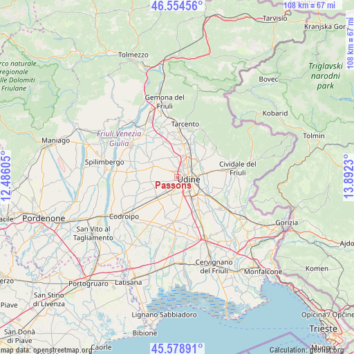
Passons GPS coordinates[2]
46° 4' 8.004" North, 13° 11' 21.012" East
| Map corner | latitude | longitude |
|---|---|---|
| Upper-left | 46.55456°, | 12.48605° |
| Center: | 46.06889°, | 13.18917° |
| Lower-right: | 45.57891°, | 13.8923° |
| Map W x H: | 108.5×108.5 km | = 67.4×67.4mi |
| max Lat: | 47.04031° ⇑6.6% North |
| Passons: | 46.06889° |
| min Lat: | ⇓93.4% South 35.50142° |
| min Long | Passons | max Long |
| 6.69888° | 13.18917° | 18.48682° |
| W 70.3%⇐ | ⇒29.7% E |
Elevation
Elevation of Passons is 114 m = 374 ft, and this is 192.7 m = 632 ft below average elevation for this country.
| Max E: |
2085 m = 6841 ft | 67.3% |
| Avg. | 306.7 m = 1006 ft | |
| Passons | 114 m = 374 ft | |
Min E: |
-4 m = -13 ft | 32.7% |
See also: Italy elevation on elevation.city.
Geographical zone
Passons is located in North temperate zone (between Tropic of Cancer and the Arctic Circle). Distance of this North polar circle is 2278.8 km =1416 mi to North.| Distance of | km | miles | from Passons |
|---|---|---|---|
| North Pole | 4884.7 | 3035.2 | to North |
| Arctic Circle | 2278.8 | 1416 | to North |
| Tropic Cancer | 2516.5 | 1563.7 | to South |
| Equator | 5122.4 | 3182.9 | to South |


Nearby cities:
15 places around Passons: (largest is in red/bold)
• Basaldella
5.3 km =3.3 mi,  155°
155°
• Brazzacco
6.3 km =3.9 mi,  338°
338°
• Bressa
5 km =3.1 mi,  220°
220°
• Campoformido
6 km =3.7 mi,  204°
204°
• Casanova
0.9 km =0.6 mi,  332°
332°
• Colloredo di Prato
4 km =2.5 mi,  240°
240°
• Colugna
2.7 km =1.7 mi,  23°
23°
• Feletto Umberto
4.6 km =2.9 mi,  33°
33°
• Martignacco
4.7 km =2.9 mi,  305°
305°
• Nogaredo di Prato
4.3 km =2.7 mi,  280°
280°
• Pagnacco
5.1 km =3.2 mi,  355°
355°
• Pasian di Prato
2.5 km =1.6 mi,  182°
182°
• Tavagnacco
5.2 km =3.2 mi, 29°
• Udine
3.7 km =2.3 mi,  89°
89°
• Zugliano-Terenzano-Cargnacco
7.2 km =4.5 mi, 162°
Sources, notices
• [Note1] Compared only with cities in Italy existing in our database
• [Src1] Map data: © OpenStreetMap contributors (CC-BY-SA)
• [Src2] Other city data from geonames.org with taken over terms of usage.
• [Src3] Geographical zone / Annual Mean Temperature by Robert A. Rohde @ Wikipedia
