Udine geodata
Udine (Friuli Venezia Giulia) is a seat of a second-order administrative division; located in Italy in Europe/Rome (GMT+2) time zone. With population of 97,761 people, there are 35 cities with bigger population in this country. Compared to other cities in Italy, 93.4% of cities are located further ↓South; 70.7% of cities are located further ←West and 66.9% of cities have higher elevation than Udine. Note1
Administrative division(s):
- Level 1: Friuli Venezia Giulia
- Level 2: Provincia di Udine
- Level 3: Udine


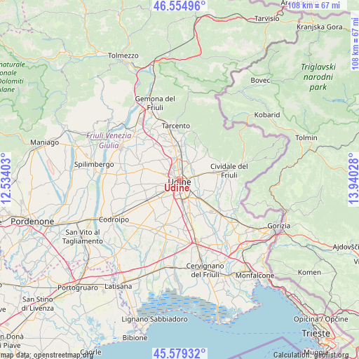
Udine GPS coordinates[2]
46° 4' 9.48" North, 13° 14' 13.74" East
| Map corner | latitude | longitude |
|---|---|---|
| Upper-left | 46.55496°, | 12.53403° |
| Center: | 46.0693°, | 13.23715° |
| Lower-right: | 45.57932°, | 13.94028° |
| Map W x H: | 108.5×108.5 km | = 67.4×67.4mi |
| max Lat: | 47.04031° ⇑6.6% North |
| Udine: | 46.0693° |
| min Lat: | ⇓93.4% South 35.50142° |
| min Long | Udine | max Long |
| 6.69888° | 13.23715° | 18.48682° |
| W 70.7%⇐ | ⇒29.3% E |
Elevation
Elevation of Udine is 116 m = 381 ft, and this is 190.7 m = 626 ft below average elevation for this country.
| Max E: |
2085 m = 6841 ft | 66.9% |
| Avg. | 306.7 m = 1006 ft | |
| Udine | 116 m = 381 ft | |
Min E: |
-4 m = -13 ft | 33.1% |
See also: Udine elevation on elevation.city.
Geographical zone
Udine is located in North temperate zone (between Tropic of Cancer and the Arctic Circle). Distance of this North polar circle is 2278.7 km =1415.9 mi to North.| Distance of | km | miles | from Udine |
|---|---|---|---|
| North Pole | 4884.6 | 3035.1 | to North |
| Arctic Circle | 2278.7 | 1415.9 | to North |
| Tropic Cancer | 2516.5 | 1563.7 | to South |
| Equator | 5122.4 | 3182.9 | to South |


Nearby cities:
15 places around Udine: (largest is in red/bold)
• Basaldella
5.1 km =3.2 mi,  197°
197°
• Cargnacco
7.3 km =4.5 mi,  181°
181°
• Casanova
4.2 km =2.6 mi,  280°
280°
• Cerneglons
5.9 km =3.7 mi,  108°
108°
• Colloredo di Prato
7.5 km =4.7 mi,  254°
254°
• Colugna
3.6 km =2.2 mi,  312°
312°
• Feletto Umberto
3.9 km =2.4 mi,  342°
342°
• Pagnacco
6.5 km =4 mi,  320°
320°
• Pasian di Prato
4.6 km =2.9 mi,  236°
236°
• Passons
3.7 km =2.3 mi,  269°
269°
• Povoletto
6.7 km =4.2 mi,  39°
39°
• Pradamano
6.4 km =4 mi,  128°
128°
• Remanzacco
6.9 km =4.3 mi,  75°
75°
• Tavagnacco
4.6 km =2.9 mi,  345°
345°
• Zugliano-Terenzano-Cargnacco
7 km =4.3 mi,  192°
192°
Sources, notices
• [Note1] Compared only with cities in Italy existing in our database
• [Src1] Map data: © OpenStreetMap contributors (CC-BY-SA)
• [Src2] Other city data from geonames.org with taken over terms of usage.
• [Src3] Geographical zone / Annual Mean Temperature by Robert A. Rohde @ Wikipedia
