Favria geodata
Favria (Piedmont) is a seat of a third-order administrative division; located in Italy in Europe/Rome (GMT+2) time zone. With population of 4,630 people, there are 2096 cities with bigger population in this country. Compared to other cities in Italy, 68.3% of cities are located further ↓South; 96.4% of cities are located further →East and 62.7% of cities have lower elevation than Favria. Note1


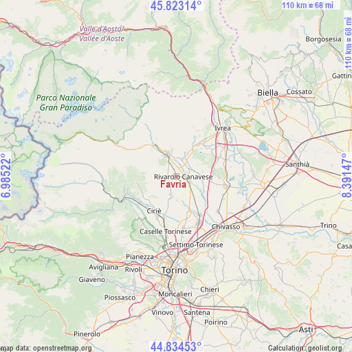
Favria GPS coordinates[2]
45° 19' 51.564" North, 7° 41' 18.024" East
| Map corner | latitude | longitude |
|---|---|---|
| Upper-left | 45.82314°, | 6.98522° |
| Center: | 45.33099°, | 7.68834° |
| Lower-right: | 44.83453°, | 8.39147° |
| Map W x H: | 109.9×109.9 km | = 68.3×68.3mi |
| max Lat: | 47.04031° ⇑31.7% North |
| Favria: | 45.33099° |
| min Lat: | ⇓68.3% South 35.50142° |
| min Long | Favria | max Long |
| 6.69888° | 7.68834° | 18.48682° |
| W 3.6%⇐ | ⇒96.4% E |
Elevation
Elevation of Favria is 320 m = 1050 ft, and this is 13.3 m = 44 ft above average elevation for this country.
| Max E: |
2085 m = 6841 ft | 37.3% |
| Favria | 320 m 1050 ft | |
| Avg. | 306.7 m = 1006 ft | |
Min E: |
-4 m = -13 ft | 62.7% |
See also: Italy elevation on elevation.city.
Geographical zone
Favria is located in North temperate zone (between Tropic of Cancer and the Arctic Circle). Distance of this North polar circle is 2360.8 km =1466.9 mi to North.| Distance of | km | miles | from Favria |
|---|---|---|---|
| North Pole | 4966.7 | 3086.2 | to North |
| Arctic Circle | 2360.8 | 1466.9 | to North |
| Tropic Cancer | 2434.4 | 1512.7 | to South |
| Equator | 5040.3 | 3131.9 | to South |


Nearby cities:
15 places around Favria: (largest is in red/bold)
• Barbania
6.1 km =3.8 mi,  223°
223°
• Busano
2.4 km =1.5 mi,  270°
270°
• Castellamonte
6 km =3.7 mi,  15°
15°
• Ciconio
5.5 km =3.4 mi,  90°
90°
• Feletto
5.4 km =3.4 mi,  124°
124°
• Front
6 km =3.7 mi,  198°
198°
• Lusigliè
6.1 km =3.8 mi,  103°
103°
• Oglianico
1.2 km =0.7 mi,  13°
13°
• Ozegna
4.8 km =3 mi,  66°
66°
• Pertusio
4.6 km =2.9 mi,  306°
306°
• Rivara
3.1 km =1.9 mi, 268°
• Rivarolo Canavese
2.6 km =1.6 mi, 96°
• Salassa
3.4 km =2.1 mi,  353°
353°
• San Ponso
2.6 km =1.6 mi,  328°
328°
• Valperga
4.8 km =3 mi, 334°
Sources, notices
• [Note1] Compared only with cities in Italy existing in our database
• [Src1] Map data: © OpenStreetMap contributors (CC-BY-SA)
• [Src2] Other city data from geonames.org with taken over terms of usage.
• [Src3] Geographical zone / Annual Mean Temperature by Robert A. Rohde @ Wikipedia
