Farra d'Alpago geodata
Farra d'Alpago (Veneto) is a seat of a third-order administrative division; located in Italy in Europe/Rome (GMT+2) time zone. With population of 1,864 people, there are 4387 cities with bigger population in this country. Compared to other cities in Italy, 94.4% of cities are located further ↓South; 60.8% of cities are located further ←West and 70.3% of cities have lower elevation than Farra d'Alpago. Note1


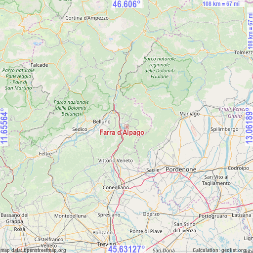
Farra d'Alpago GPS coordinates[2]
46° 7' 14.844" North, 12° 21' 31.536" East
| Map corner | latitude | longitude |
|---|---|---|
| Upper-left | 46.606°, | 11.65564° |
| Center: | 46.12079°, | 12.35876° |
| Lower-right: | 45.63127°, | 13.06189° |
| Map W x H: | 108.4×108.4 km | = 67.4×67.4mi |
| max Lat: | 47.04031° ⇑5.6% North |
| Farra d'Alpago: | 46.12079° |
| min Lat: | ⇓94.4% South 35.50142° |
| min Long | Farra d'Alpago | max Long |
| 6.69888° | 12.35876° | 18.48682° |
| W 60.8%⇐ | ⇒39.2% E |
Elevation
Elevation of Farra d'Alpago is 398 m = 1306 ft, and this is 91.3 m = 300 ft above average elevation for this country.
| Max E: |
2085 m = 6841 ft | 29.7% |
| Farra d'Alpago | 398 m 1306 ft | |
| Avg. | 306.7 m = 1006 ft | |
Min E: |
-4 m = -13 ft | 70.3% |
See also: Italy elevation on elevation.city.
Geographical zone
Farra d'Alpago is located in North temperate zone (between Tropic of Cancer and the Arctic Circle). Distance of this North polar circle is 2273 km =1412.4 mi to North.| Distance of | km | miles | from Farra d'Alpago |
|---|---|---|---|
| North Pole | 4878.9 | 3031.6 | to North |
| Arctic Circle | 2273 | 1412.4 | to North |
| Tropic Cancer | 2522.2 | 1567.2 | to South |
| Equator | 5128.2 | 3186.5 | to South |


Nearby cities:
15 places around Farra d'Alpago: (largest is in red/bold)
• Belluno
11.3 km =7 mi,  282°
282°
• Caleipo-Sossai
8.1 km =5 mi,  272°
272°
• Castion
9.5 km =5.9 mi, 270°
• Cornei
2.8 km =1.7 mi,  37°
37°
• Lamosano
6.2 km =3.9 mi,  20°
20°
• Levego
8.3 km =5.2 mi,  299°
299°
• Nove-San Floriano
9.7 km =6 mi,  203°
203°
• Osigo
12.1 km =7.5 mi,  183°
183°
• Pieve d'Alpago
5.1 km =3.2 mi,  355°
355°
• Ponte nelle Alpi
8.9 km =5.5 mi,  318°
318°
• Ponte nelle Alpi-Polpet
9.7 km =6 mi, 320°
• Puos d'Alpago
2.3 km =1.4 mi,  5°
5°
• Soccher-Paiane-Casan-Arsie
7.7 km =4.8 mi,  330°
330°
• Soverzene
10.1 km =6.3 mi, 334°
• Tambre
4.7 km =2.9 mi,  82°
82°
Sources, notices
• [Note1] Compared only with cities in Italy existing in our database
• [Src1] Map data: © OpenStreetMap contributors (CC-BY-SA)
• [Src2] Other city data from geonames.org with taken over terms of usage.
• [Src3] Geographical zone / Annual Mean Temperature by Robert A. Rohde @ Wikipedia
