Lamosano geodata
Lamosano (Veneto) is a seat of a third-order administrative division; located in Italy in Europe/Rome (GMT+2) time zone. With population of 249 people, there are 10899 cities with bigger population in this country. Compared to other cities in Italy, 95.6% of cities are located further ↓South; 61.1% of cities are located further ←West and 86.5% of cities have lower elevation than Lamosano. Note1


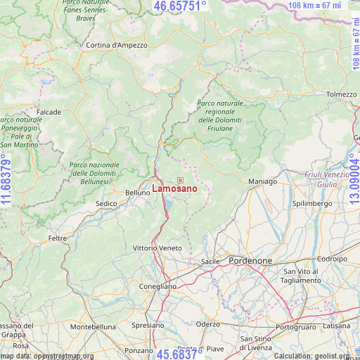
Lamosano GPS coordinates[2]
46° 10' 21.936" North, 12° 23' 12.876" East
| Map corner | latitude | longitude |
|---|---|---|
| Upper-left | 46.65751°, | 11.68379° |
| Center: | 46.17276°, | 12.38691° |
| Lower-right: | 45.6837°, | 13.09004° |
| Map W x H: | 108.3×108.3 km | = 67.3×67.3mi |
| max Lat: | 47.04031° ⇑4.4% North |
| Lamosano: | 46.17276° |
| min Lat: | ⇓95.6% South 35.50142° |
| min Long | Lamosano | max Long |
| 6.69888° | 12.38691° | 18.48682° |
| W 61.1%⇐ | ⇒38.9% E |
Elevation
Elevation of Lamosano is 642 m = 2106 ft, and this is 335.3 m = 1100 ft above average elevation for this country.
| Max E: |
2085 m = 6841 ft | 13.5% |
| Lamosano | 642 m 2106 ft | |
| Avg. | 306.7 m = 1006 ft | |
Min E: |
-4 m = -13 ft | 86.5% |
See also: Italy elevation on elevation.city.
Geographical zone
Lamosano is located in North temperate zone (between Tropic of Cancer and the Arctic Circle). Distance of this North polar circle is 2267.2 km =1408.8 mi to North.| Distance of | km | miles | from Lamosano |
|---|---|---|---|
| North Pole | 4873.1 | 3028 | to North |
| Arctic Circle | 2267.2 | 1408.8 | to North |
| Tropic Cancer | 2528 | 1570.8 | to South |
| Equator | 5133.9 | 3190.1 | to South |


Nearby cities:
15 places around Lamosano: (largest is in red/bold)
• Caleipo-Sossai
11.6 km =7.2 mi,  241°
241°
• Codissago
12.9 km =8 mi,  332°
332°
• Cornei
3.6 km =2.2 mi,  187°
187°
• Erto
11.6 km =7.2 mi,  354°
354°
• Farra d'Alpago
6.2 km =3.9 mi,  200°
200°
• Fortogna
9.8 km =6.1 mi,  310°
310°
• Levego
9.6 km =6 mi,  259°
259°
• Longarone
12.3 km =7.6 mi, 327°
• Pieve d'Alpago
2.7 km =1.7 mi, 255°
• Ponte nelle Alpi
8 km =5 mi,  276°
276°
• Ponte nelle Alpi-Polpet
8.5 km =5.3 mi, 281°
• Puos d'Alpago
4 km =2.5 mi,  209°
209°
• Soccher-Paiane-Casan-Arsie
6 km =3.7 mi, 279°
• Soverzene
7.3 km =4.5 mi,  297°
297°
• Tambre
5.7 km =3.5 mi,  154°
154°
Sources, notices
• [Note1] Compared only with cities in Italy existing in our database
• [Src1] Map data: © OpenStreetMap contributors (CC-BY-SA)
• [Src2] Other city data from geonames.org with taken over terms of usage.
• [Src3] Geographical zone / Annual Mean Temperature by Robert A. Rohde @ Wikipedia
