Erba geodata
Erba (Lombardy) is a seat of a third-order administrative division; located in Italy in Europe/Rome (GMT+2) time zone. With population of 16,431 people, there are 554 cities with bigger population in this country. Compared to other cities in Italy, 86.1% of cities are located further ↓South; 77.6% of cities are located further →East and 57.3% of cities have lower elevation than Erba. Note1


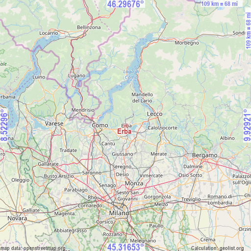
Erba GPS coordinates[2]
45° 48' 31.68" North, 9° 13' 33.924" East
| Map corner | latitude | longitude |
|---|---|---|
| Upper-left | 46.29676°, | 8.52296° |
| Center: | 45.8088°, | 9.22609° |
| Lower-right: | 45.31653°, | 9.92921° |
| Map W x H: | 109×109 km | = 67.7×67.7mi |
| max Lat: | 47.04031° ⇑13.9% North |
| Erba: | 45.8088° |
| min Lat: | ⇓86.1% South 35.50142° |
| min Long | Erba | max Long |
| 6.69888° | 9.22609° | 18.48682° |
| W 22.4%⇐ | ⇒77.6% E |
Elevation
Elevation of Erba is 281 m = 922 ft, and this is 25.7 m = 84 ft below average elevation for this country.
| Max E: |
2085 m = 6841 ft | 42.7% |
| Avg. | 306.7 m = 1006 ft | |
| Erba | 281 m = 922 ft | |
Min E: |
-4 m = -13 ft | 57.3% |
See also: Italy elevation on elevation.city.
Geographical zone
Erba is located in North temperate zone (between Tropic of Cancer and the Arctic Circle). Distance of this North polar circle is 2307.7 km =1433.9 mi to North.| Distance of | km | miles | from Erba |
|---|---|---|---|
| North Pole | 4913.6 | 3053.2 | to North |
| Arctic Circle | 2307.7 | 1433.9 | to North |
| Tropic Cancer | 2487.5 | 1545.7 | to South |
| Equator | 5093.5 | 3165 | to South |


Nearby cities:
15 places around Erba: (largest is in red/bold)
• Albavilla
3.3 km =2.1 mi,  253°
253°
• Alserio
3.9 km =2.4 mi,  211°
211°
• Anzano del Parco
4.8 km =3 mi, 207°
• Caslino d'Erba
3.4 km =2.1 mi,  359°
359°
• Castelmarte
2.7 km =1.7 mi,  11°
11°
• Corneno-Galliano-Carella Mariaga
3.3 km =2.1 mi,  74°
74°
• Longone al Segrino
2.1 km =1.3 mi, 72°
• Merone
2.8 km =1.7 mi,  149°
149°
• Nobile-Monguzzo
3.2 km =2 mi,  174°
174°
• Penzano
2.5 km =1.6 mi,  86°
86°
• Ponte Lambro
1.8 km =1.1 mi, 356°
• Proserpio
2.6 km =1.6 mi,  34°
34°
• Pusiano
4.4 km =2.7 mi,  81°
81°
• Rogeno
4.7 km =2.9 mi,  128°
128°
• Vill'Albese
3.2 km =2 mi, 245°
Sources, notices
• [Note1] Compared only with cities in Italy existing in our database
• [Src1] Map data: © OpenStreetMap contributors (CC-BY-SA)
• [Src2] Other city data from geonames.org with taken over terms of usage.
• [Src3] Geographical zone / Annual Mean Temperature by Robert A. Rohde @ Wikipedia
