Alserio geodata
Alserio (Lombardy) is a seat of a third-order administrative division; located in Italy in Europe/Rome (GMT+2) time zone. With population of 1,106 people, there are 6271 cities with bigger population in this country. Compared to other cities in Italy, 84.8% of cities are located further ↓South; 78% of cities are located further →East and 54.9% of cities have lower elevation than Alserio. Note1


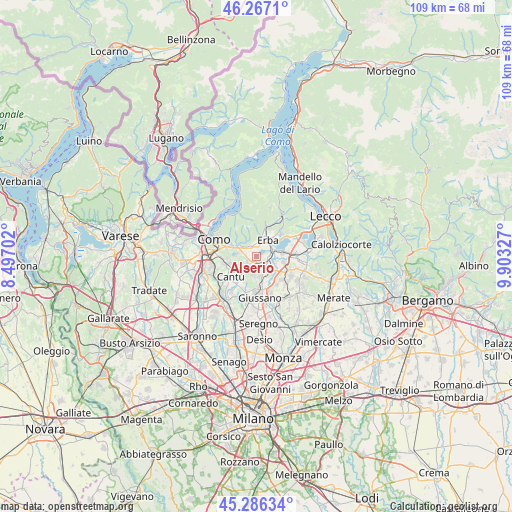
Alserio GPS coordinates[2]
45° 46' 43.968" North, 9° 12' 0.504" East
| Map corner | latitude | longitude |
|---|---|---|
| Upper-left | 46.2671°, | 8.49702° |
| Center: | 45.77888°, | 9.20014° |
| Lower-right: | 45.28634°, | 9.90327° |
| Map W x H: | 109.1×10⁹ km | = 67.8×67.7mi |
| max Lat: | 47.04031° ⇑15.2% North |
| Alserio: | 45.77888° |
| min Lat: | ⇓84.8% South 35.50142° |
| min Long | Alserio | max Long |
| 6.69888° | 9.20014° | 18.48682° |
| W 22%⇐ | ⇒78% E |
Elevation
Elevation of Alserio is 265 m = 869 ft, and this is 41.7 m = 137 ft below average elevation for this country.
| Max E: |
2085 m = 6841 ft | 45.1% |
| Avg. | 306.7 m = 1006 ft | |
| Alserio | 265 m = 869 ft | |
Min E: |
-4 m = -13 ft | 54.9% |
See also: Italy elevation on elevation.city.
Geographical zone
Alserio is located in North temperate zone (between Tropic of Cancer and the Arctic Circle). Distance of this North polar circle is 2311 km =1436 mi to North.| Distance of | km | miles | from Alserio |
|---|---|---|---|
| North Pole | 4916.9 | 3055.2 | to North |
| Arctic Circle | 2311 | 1436 | to North |
| Tropic Cancer | 2484.2 | 1543.6 | to South |
| Equator | 5090.1 | 3162.8 | to South |


Nearby cities:
15 places around Alserio: (largest is in red/bold)
• Albavilla
2.7 km =1.7 mi,  333°
333°
• Albese Con Cassano
3.3 km =2.1 mi,  302°
302°
• Alzate Brianza
1.7 km =1.1 mi,  234°
234°
• Anzano del Parco
1 km =0.6 mi,  191°
191°
• Brenna
4.1 km =2.5 mi, 194°
• Camisasca
4.5 km =2.8 mi,  107°
107°
• Erba
3.9 km =2.4 mi,  31°
31°
• Fabbrica Durini
3.1 km =1.9 mi, 186°
• Lambrugo
3.8 km =2.4 mi,  126°
126°
• Lurago d'Erba
3.4 km =2.1 mi,  155°
155°
• Merone
3.5 km =2.2 mi,  74°
74°
• Montorfano
4.5 km =2.8 mi,  280°
280°
• Nobile-Monguzzo
2.3 km =1.4 mi,  86°
86°
• Orsenigo
1.6 km =1 mi,  268°
268°
• Vill'Albese
2.2 km =1.4 mi,  335°
335°
Sources, notices
• [Note1] Compared only with cities in Italy existing in our database
• [Src1] Map data: © OpenStreetMap contributors (CC-BY-SA)
• [Src2] Other city data from geonames.org with taken over terms of usage.
• [Src3] Geographical zone / Annual Mean Temperature by Robert A. Rohde @ Wikipedia
