Eraclea geodata
Eraclea (Veneto) is a seat of a third-order administrative division; located in Italy in Europe/Rome (GMT+2) time zone. With population of 4,104 people, there are 2340 cities with bigger population in this country. Compared to other cities in Italy, 76.1% of cities are located further ↓South; 64.6% of cities are located further ←West and 99% of cities have higher elevation than Eraclea. Note1


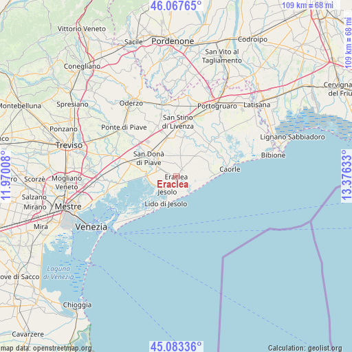
Eraclea GPS coordinates[2]
45° 34' 39.576" North, 12° 40' 23.52" East
| Map corner | latitude | longitude |
|---|---|---|
| Upper-left | 46.06765°, | 11.97008° |
| Center: | 45.57766°, | 12.6732° |
| Lower-right: | 45.08336°, | 13.37633° |
| Map W x H: | 109.4×109.4 km | = 68×68mi |
| max Lat: | 47.04031° ⇑23.9% North |
| Eraclea: | 45.57766° |
| min Lat: | ⇓76.1% South 35.50142° |
| min Long | Eraclea | max Long |
| 6.69888° | 12.6732° | 18.48682° |
| W 64.6%⇐ | ⇒35.4% E |
Elevation
Elevation of Eraclea is 2 m = 7 ft, and this is 304.7 m = 1000 ft below average elevation for this country.
| Max E: |
2085 m = 6841 ft | 99% |
| Avg. | 306.7 m = 1006 ft | |
| Eraclea | 2 m = 7 ft | |
Min E: |
-4 m = -13 ft | 1% |
See also: Italy elevation on elevation.city.
Geographical zone
Eraclea is located in North temperate zone (between Tropic of Cancer and the Arctic Circle). Distance of this North polar circle is 2333.4 km =1449.9 mi to North.| Distance of | km | miles | from Eraclea |
|---|---|---|---|
| North Pole | 4939.3 | 3069.1 | to North |
| Arctic Circle | 2333.4 | 1449.9 | to North |
| Tropic Cancer | 2461.8 | 1529.7 | to South |
| Equator | 5067.8 | 3149 | to South |


Nearby cities:
15 places around Eraclea: (largest is in red/bold)
• Calnova-Fiorentina
8.3 km =5.2 mi,  323°
323°
• Ceggia
12.4 km =7.7 mi,  348°
348°
• Chiesanuova
7.6 km =4.7 mi,  287°
287°
• Crepaldo
2.6 km =1.6 mi,  43°
43°
• Croce
13.2 km =8.2 mi,  297°
297°
• Iesolo
5.4 km =3.4 mi,  204°
204°
• La Salute di Livenza
13.1 km =8.1 mi,  49°
49°
• Lido di Jesolo
8.1 km =5 mi,  194°
194°
• Musile di Piave
11.3 km =7 mi, 295°
• Passarella
5.6 km =3.5 mi, 289°
• San Donà di Piave
10 km =6.2 mi,  305°
305°
• San Giorgio di Livenza
12.8 km =8 mi, 48°
• Stretti
6.6 km =4.1 mi,  10°
10°
• Torre di Fine
6.1 km =3.8 mi,  102°
102°
• Torre di Mosto
12.3 km =7.6 mi, 9°
Sources, notices
• [Note1] Compared only with cities in Italy existing in our database
• [Src1] Map data: © OpenStreetMap contributors (CC-BY-SA)
• [Src2] Other city data from geonames.org with taken over terms of usage.
• [Src3] Geographical zone / Annual Mean Temperature by Robert A. Rohde @ Wikipedia
