Cursi geodata
Cursi (Apulia) is a seat of a third-order administrative division; located in Italy in Europe/Rome (GMT+2) time zone. With population of 4,013 people, there are 2387 cities with bigger population in this country. Compared to other cities in Italy, 86.8% of cities are located further ↑North; 99.6% of cities are located further ←West and 72.2% of cities have higher elevation than Cursi. Note1


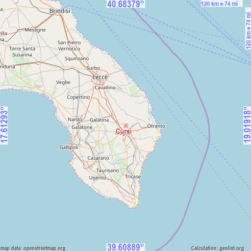
Cursi GPS coordinates[2]
40° 8' 54.492" North, 18° 18' 57.78" East
| Map corner | latitude | longitude |
|---|---|---|
| Upper-left | 40.68379°, | 17.61293° |
| Center: | 40.14847°, | 18.31605° |
| Lower-right: | 39.60889°, | 19.01918° |
| Map W x H: | 119.5×119.5 km | = 74.3×74.3mi |
| max Lat: | 47.04031° ⇑86.8% North |
| Cursi: | 40.14847° |
| min Lat: | ⇓13.2% South 35.50142° |
| min Long | Cursi | max Long |
| 6.69888° | 18.31605° | 18.48682° |
| W 99.6%⇐ | ⇒0.40000000000001% E |
Elevation
Elevation of Cursi is 87 m = 285 ft, and this is 219.7 m = 721 ft below average elevation for this country.
| Max E: |
2085 m = 6841 ft | 72.2% |
| Avg. | 306.7 m = 1006 ft | |
| Cursi | 87 m = 285 ft | |
Min E: |
-4 m = -13 ft | 27.8% |
See also: Italy elevation on elevation.city.
Geographical zone
Cursi is located in North temperate zone (between Tropic of Cancer and the Arctic Circle). Distance of this Northern Tropic circle is 1858.2 km =1154.6 mi to South.| Distance of | km | miles | from Cursi |
|---|---|---|---|
| North Pole | 5543 | 3444.3 | to North |
| Arctic Circle | 2937.1 | 1825 | to North |
| Tropic Cancer | 1858.2 | 1154.6 | to South |
| Equator | 4464.1 | 2773.9 | to South |


Nearby cities:
15 places around Cursi: (largest is in red/bold)
• Bagnolo del Salento
3.1 km =1.9 mi,  88°
88°
• Cannole
4.6 km =2.9 mi,  64°
64°
• Carpignano Salentino
5.5 km =3.4 mi,  19°
19°
• Castrignano De' Greci
3.2 km =2 mi,  328°
328°
• Corigliano d'Otranto
5.2 km =3.2 mi,  283°
283°
• Giuggianello
7.6 km =4.7 mi,  143°
143°
• Maglie
3.5 km =2.2 mi,  206°
206°
• Martano
6.1 km =3.8 mi,  348°
348°
• Melpignano
2.2 km =1.4 mi,  292°
292°
• Muro Leccese
5.4 km =3.4 mi,  160°
160°
• Palmariggi
5.7 km =3.5 mi,  110°
110°
• Sanarica
7.1 km =4.4 mi, 157°
• Scorrano
6.6 km =4.1 mi,  191°
191°
• Serrano
5 km =3.1 mi,  37°
37°
• Zollino
8.6 km =5.3 mi,  317°
317°
Sources, notices
• [Note1] Compared only with cities in Italy existing in our database
• [Src1] Map data: © OpenStreetMap contributors (CC-BY-SA)
• [Src2] Other city data from geonames.org with taken over terms of usage.
• [Src3] Geographical zone / Annual Mean Temperature by Robert A. Rohde @ Wikipedia
