Cannole geodata
Cannole (Apulia) is a seat of a third-order administrative division; located in Italy in Europe/Rome (GMT+2) time zone. With population of 1,639 people, there are 4803 cities with bigger population in this country. Compared to other cities in Italy, 86.6% of cities are located further ↑North; 99.8% of cities are located further ←West and 71.3% of cities have higher elevation than Cannole. Note1


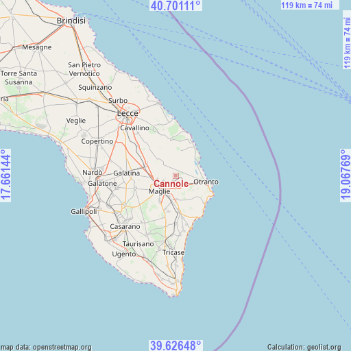
Cannole GPS coordinates[2]
40° 9' 57.312" North, 18° 21' 52.416" East
| Map corner | latitude | longitude |
|---|---|---|
| Upper-left | 40.70111°, | 17.66144° |
| Center: | 40.16592°, | 18.36456° |
| Lower-right: | 39.62648°, | 19.06769° |
| Map W x H: | 119.5×119.5 km | = 74.3×74.3mi |
| max Lat: | 47.04031° ⇑86.6% North |
| Cannole: | 40.16592° |
| min Lat: | ⇓13.4% South 35.50142° |
| min Long | Cannole | max Long |
| 6.69888° | 18.36456° | 18.48682° |
| W 99.8%⇐ | ⇒0.2% E |
Elevation
Elevation of Cannole is 91 m = 299 ft, and this is 215.7 m = 708 ft below average elevation for this country.
| Max E: |
2085 m = 6841 ft | 71.3% |
| Avg. | 306.7 m = 1006 ft | |
| Cannole | 91 m = 299 ft | |
Min E: |
-4 m = -13 ft | 28.7% |
See also: Italy elevation on elevation.city.
Geographical zone
Cannole is located in North temperate zone (between Tropic of Cancer and the Arctic Circle). Distance of this Northern Tropic circle is 1860.1 km =1155.8 mi to South.| Distance of | km | miles | from Cannole |
|---|---|---|---|
| North Pole | 5541 | 3443 | to North |
| Arctic Circle | 2935.1 | 1823.8 | to North |
| Tropic Cancer | 1860.1 | 1155.8 | to South |
| Equator | 4466 | 2775 | to South |


Nearby cities:
15 places around Cannole: (largest is in red/bold)
• Bagnolo del Salento
2.2 km =1.4 mi,  209°
209°
• Borgagne
8.4 km =5.2 mi,  6°
6°
• Carpignano Salentino
4 km =2.5 mi,  325°
325°
• Casamassella
9.3 km =5.8 mi,  128°
128°
• Castrignano De' Greci
5.8 km =3.6 mi,  278°
278°
• Cursi
4.6 km =2.9 mi,  244°
244°
• Giuggianello
8 km =5 mi,  177°
177°
• Giurdignano
7.4 km =4.6 mi, 129°
• Maglie
7.6 km =4.7 mi,  228°
228°
• Martano
6.7 km =4.2 mi,  307°
307°
• Melpignano
6.3 km =3.9 mi,  260°
260°
• Muro Leccese
7.4 km =4.6 mi,  198°
198°
• Palmariggi
4.1 km =2.5 mi,  162°
162°
• Sanarica
8.7 km =5.4 mi,  189°
189°
• Serrano
2.3 km =1.4 mi, 331°
Sources, notices
• [Note1] Compared only with cities in Italy existing in our database
• [Src1] Map data: © OpenStreetMap contributors (CC-BY-SA)
• [Src2] Other city data from geonames.org with taken over terms of usage.
• [Src3] Geographical zone / Annual Mean Temperature by Robert A. Rohde @ Wikipedia
