Nicorvo geodata
Nicorvo (Lombardy) is a seat of a third-order administrative division; located in Italy in Europe/Rome (GMT+1) time zone. With population of 341 people, there are 10512 cities with bigger population in this country. Compared to other cities in Italy, 67.1% of cities are located further ↓South; 85.9% of cities are located further →East and 67.1% of cities have higher elevation than Nicorvo. Note1


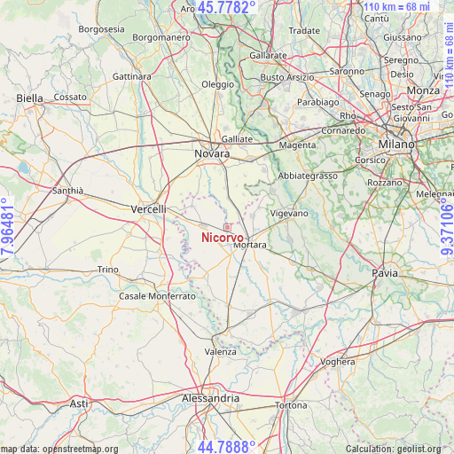
Nicorvo GPS coordinates[2]
45° 17' 8.376" North, 8° 40' 4.584" East
| Map corner | latitude | longitude |
|---|---|---|
| Upper-left | 45.7782°, | 7.96481° |
| Center: | 45.28566°, | 8.66794° |
| Lower-right: | 44.7888°, | 9.37106° |
| Map W x H: | 110×110 km | = 68.4×68.4mi |
| max Lat: | 47.04031° ⇑32.9% North |
| Nicorvo: | 45.28566° |
| min Lat: | ⇓67.1% South 35.50142° |
| min Long | Nicorvo | max Long |
| 6.69888° | 8.66794° | 18.48682° |
| W 14.1%⇐ | ⇒85.9% E |
Elevation
Elevation of Nicorvo is 115 m = 377 ft, and this is 191.7 m = 629 ft below average elevation for this country.
| Max E: |
2085 m = 6841 ft | 67.1% |
| Avg. | 306.7 m = 1006 ft | |
| Nicorvo | 115 m = 377 ft | |
Min E: |
-4 m = -13 ft | 32.9% |
See also: Italy elevation on elevation.city.
Geographical zone
Nicorvo is located in North temperate zone (between Tropic of Cancer and the Arctic Circle). Distance of this North polar circle is 2365.9 km =1470.1 mi to North.| Distance of | km | miles | from Nicorvo |
|---|---|---|---|
| North Pole | 4971.8 | 3089.3 | to North |
| Arctic Circle | 2365.9 | 1470.1 | to North |
| Tropic Cancer | 2429.4 | 1509.6 | to South |
| Equator | 5035.3 | 3128.8 | to South |


Nearby cities:
15 places around Nicorvo: (largest is in red/bold)
• Albonese
3.1 km =1.9 mi,  75°
75°
• Borgolavezzaro
4.5 km =2.8 mi,  33°
33°
• Castello d'Agogna
5.9 km =3.7 mi,  165°
165°
• Castelnovetto
5.6 km =3.5 mi,  231°
231°
• Ceretto Lomellina
4.5 km =2.8 mi,  175°
175°
• Cilavegna
6.6 km =4.1 mi,  65°
65°
• Gravellona
8.9 km =5.5 mi,  58°
58°
• Mortara
6.5 km =4 mi,  128°
128°
• Olevano di Lomellina
8.9 km =5.5 mi,  154°
154°
• Parona
6.5 km =4 mi,  93°
93°
• Robbio
5.9 km =3.7 mi,  273°
273°
• Rosasco
8 km =5 mi,  240°
240°
• Sant'Angelo Lomellina
4.8 km =3 mi,  204°
204°
• Tornaco
8.8 km =5.5 mi, 26°
• Vespolate
7.1 km =4.4 mi,  0°
0°
Sources, notices
• [Note1] Compared only with cities in Italy existing in our database
• [Src1] Map data: © OpenStreetMap contributors (CC-BY-SA)
• [Src2] Other city data from geonames.org with taken over terms of usage.
• [Src3] Geographical zone / Annual Mean Temperature by Robert A. Rohde @ Wikipedia
