Concadirame geodata
Concadirame (Veneto) is a populated place; located in Italy in Europe/Rome (GMT+2) time zone. With population of 818 people, there are 7553 cities with bigger population in this country. Compared to other cities in Italy, 62.2% of cities are located further ↓South; 52.2% of cities are located further ←West and 97.2% of cities have higher elevation than Concadirame. Note1


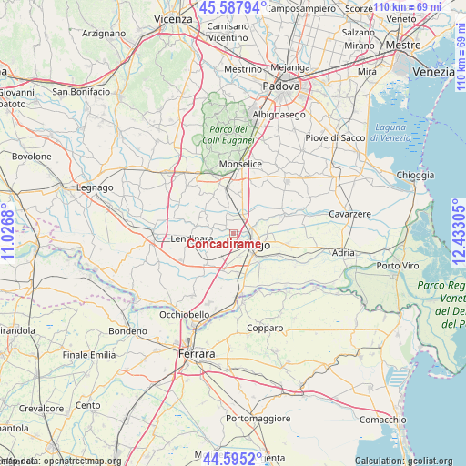
Concadirame GPS coordinates[2]
45° 5' 37.428" North, 11° 43' 47.712" East
| Map corner | latitude | longitude |
|---|---|---|
| Upper-left | 45.58794°, | 11.0268° |
| Center: | 45.09373°, | 11.72992° |
| Lower-right: | 44.5952°, | 12.43305° |
| Map W x H: | 110.4×110.4 km | = 68.6×68.6mi |
| max Lat: | 47.04031° ⇑37.8% North |
| Concadirame: | 45.09373° |
| min Lat: | ⇓62.2% South 35.50142° |
| min Long | Concadirame | max Long |
| 6.69888° | 11.72992° | 18.48682° |
| W 52.2%⇐ | ⇒47.8% E |
Elevation
Elevation of Concadirame is 5 m = 16 ft, and this is 301.7 m = 990 ft below average elevation for this country.
| Max E: |
2085 m = 6841 ft | 97.2% |
| Avg. | 306.7 m = 1006 ft | |
| Concadirame | 5 m = 16 ft | |
Min E: |
-4 m = -13 ft | 2.8% |
See also: Italy elevation on elevation.city.
Geographical zone
Concadirame is located in North temperate zone (between Tropic of Cancer and the Arctic Circle). Distance of this North polar circle is 2387.2 km =1483.3 mi to North.| Distance of | km | miles | from Concadirame |
|---|---|---|---|
| North Pole | 4993.1 | 3102.6 | to North |
| Arctic Circle | 2387.2 | 1483.3 | to North |
| Tropic Cancer | 2408 | 1496.3 | to South |
| Equator | 5014 | 3115.6 | to South |


Nearby cities:
15 places around Concadirame: (largest is in red/bold)
• Arquà Polesine
9.3 km =5.8 mi,  175°
175°
• Barbona
2.2 km =1.4 mi,  298°
298°
• Boara Pisani
4.4 km =2.7 mi,  68°
68°
• Ca' Morosini
9 km =5.6 mi,  283°
283°
• Carmignano
9.1 km =5.7 mi,  314°
314°
• Costa di Rovigo
5.4 km =3.4 mi,  210°
210°
• Granze
7.1 km =4.4 mi,  350°
350°
• Grignano Polesine
5.7 km =3.5 mi,  166°
166°
• Lusia
5.1 km =3.2 mi, 275°
• Mardimago
8.6 km =5.3 mi,  80°
80°
• Pisana
8.8 km =5.5 mi,  12°
12°
• Rovigo
5.4 km =3.4 mi,  119°
119°
• Stanghella
5.1 km =3.2 mi,  25°
25°
• Vescovana
4.7 km =2.9 mi,  343°
343°
• Villanova del Ghebbo Canton
7.8 km =4.8 mi,  240°
240°
Sources, notices
• [Note1] Compared only with cities in Italy existing in our database
• [Src1] Map data: © OpenStreetMap contributors (CC-BY-SA)
• [Src2] Other city data from geonames.org with taken over terms of usage.
• [Src3] Geographical zone / Annual Mean Temperature by Robert A. Rohde @ Wikipedia
