Rovigo geodata
Rovigo (Veneto) is a seat of a second-order administrative division; located in Italy in Europe/Rome (GMT+2) time zone. With population of 39,347 people, there are 182 cities with bigger population in this country. Compared to other cities in Italy, 61.7% of cities are located further ↓South; 53% of cities are located further ←West and 93.6% of cities have higher elevation than Rovigo. Note1


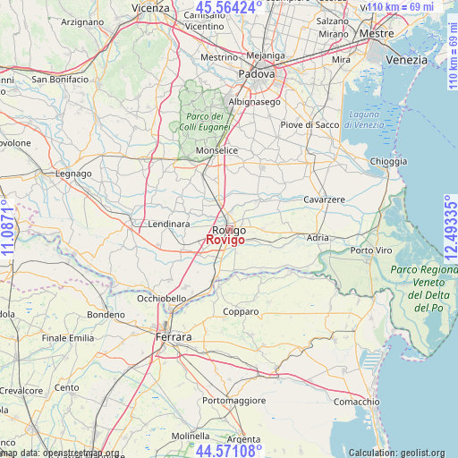
Rovigo GPS coordinates[2]
45° 4' 11.352" North, 11° 47' 24.792" East
| Map corner | latitude | longitude |
|---|---|---|
| Upper-left | 45.56424°, | 11.0871° |
| Center: | 45.06982°, | 11.79022° |
| Lower-right: | 44.57108°, | 12.49335° |
| Map W x H: | 110.4×110.4 km | = 68.6×68.6mi |
| max Lat: | 47.04031° ⇑38.3% North |
| Rovigo: | 45.06982° |
| min Lat: | ⇓61.7% South 35.50142° |
| min Long | Rovigo | max Long |
| 6.69888° | 11.79022° | 18.48682° |
| W 53%⇐ | ⇒47% E |
Elevation
Elevation of Rovigo is 11 m = 36 ft, and this is 295.7 m = 970 ft below average elevation for this country.
| Max E: |
2085 m = 6841 ft | 93.6% |
| Avg. | 306.7 m = 1006 ft | |
| Rovigo | 11 m = 36 ft | |
Min E: |
-4 m = -13 ft | 6.4% |
See also: Italy elevation on elevation.city.
Geographical zone
Rovigo is located in North temperate zone (between Tropic of Cancer and the Arctic Circle). Distance of this North polar circle is 2389.9 km =1485 mi to North.| Distance of | km | miles | from Rovigo |
|---|---|---|---|
| North Pole | 4995.8 | 3104.2 | to North |
| Arctic Circle | 2389.9 | 1485 | to North |
| Tropic Cancer | 2405.4 | 1494.6 | to South |
| Equator | 5011.3 | 3113.9 | to South |


Nearby cities:
15 places around Rovigo: (largest is in red/bold)
• Arquà Polesine
7.7 km =4.8 mi,  210°
210°
• Barbona
7.7 km =4.8 mi,  299°
299°
• Boara Pisani
4.3 km =2.7 mi,  352°
352°
• Bosaro
8.1 km =5 mi,  194°
194°
• Buso
4.5 km =2.8 mi,  96°
96°
• Ceregnano
6.6 km =4.1 mi,  111°
111°
• Concadirame
5.4 km =3.4 mi, 299°
• Costa di Rovigo
7.7 km =4.8 mi,  254°
254°
• Grignano Polesine
4.5 km =2.8 mi,  229°
229°
• Mardimago
5.6 km =3.5 mi,  41°
41°
• Pontecchio Polesine
5.8 km =3.6 mi,  161°
161°
• San Martino di Venezze
8.8 km =5.5 mi,  45°
45°
• Sant'Apollinare
4.2 km =2.6 mi,  139°
139°
• Stanghella
7.7 km =4.8 mi,  340°
340°
• Villadose
8.5 km =5.3 mi,  88°
88°
Sources, notices
• [Note1] Compared only with cities in Italy existing in our database
• [Src1] Map data: © OpenStreetMap contributors (CC-BY-SA)
• [Src2] Other city data from geonames.org with taken over terms of usage.
• [Src3] Geographical zone / Annual Mean Temperature by Robert A. Rohde @ Wikipedia
