Brunate geodata
Brunate (Lombardy) is a seat of a third-order administrative division; located in Italy in Europe/Rome (GMT+2) time zone. With population of 1,679 people, there are 4712 cities with bigger population in this country. Compared to other cities in Italy, 86.7% of cities are located further ↓South; 79.7% of cities are located further →East and 89.6% of cities have lower elevation than Brunate. Note1


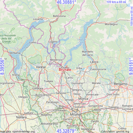
Brunate GPS coordinates[2]
45° 49' 15.456" North, 9° 5' 55.284" East
| Map corner | latitude | longitude |
|---|---|---|
| Upper-left | 46.30881°, | 8.39556° |
| Center: | 45.82096°, | 9.09869° |
| Lower-right: | 45.32879°, | 9.80181° |
| Map W x H: | 109×109 km | = 67.7×67.7mi |
| max Lat: | 47.04031° ⇑13.3% North |
| Brunate: | 45.82096° |
| min Lat: | ⇓86.7% South 35.50142° |
| min Long | Brunate | max Long |
| 6.69888° | 9.09869° | 18.48682° |
| W 20.3%⇐ | ⇒79.7% E |
Elevation
Elevation of Brunate is 711 m = 2333 ft, and this is 404.3 m = 1326 ft above average elevation for this country.
| Max E: |
2085 m = 6841 ft | 10.4% |
| Brunate | 711 m 2333 ft | |
| Avg. | 306.7 m = 1006 ft | |
Min E: |
-4 m = -13 ft | 89.6% |
See also: Italy elevation on elevation.city.
Geographical zone
Brunate is located in North temperate zone (between Tropic of Cancer and the Arctic Circle). Distance of this North polar circle is 2306.4 km =1433.1 mi to North.| Distance of | km | miles | from Brunate |
|---|---|---|---|
| North Pole | 4912.2 | 3052.3 | to North |
| Arctic Circle | 2306.4 | 1433.1 | to North |
| Tropic Cancer | 2488.9 | 1546.5 | to South |
| Equator | 5094.8 | 3165.8 | to South |


Nearby cities:
15 places around Brunate: (largest is in red/bold)
• Albese Con Cassano
5.8 km =3.6 mi,  119°
119°
• Blevio
2.4 km =1.5 mi,  11°
11°
• Carate Urio
5.9 km =3.7 mi,  17°
17°
• Cavallasca
5.3 km =3.3 mi,  256°
256°
• Cernobbio
3.2 km =2 mi,  319°
319°
• Como
1.9 km =1.2 mi,  220°
220°
• Lipomo
3.5 km =2.2 mi,  151°
151°
• Lucino
6 km =3.7 mi,  225°
225°
• Maslianico
4.6 km =2.9 mi,  302°
302°
• Moltrasio
4.3 km =2.7 mi,  359°
359°
• Montano Lucino
6 km =3.7 mi, 226°
• Montorfano
5.2 km =3.2 mi,  137°
137°
• San Fermo della Battaglia
4.2 km =2.6 mi,  251°
251°
• Tavernerio
4 km =2.5 mi, 124°
• Torno
4.1 km =2.5 mi, 20°
Sources, notices
• [Note1] Compared only with cities in Italy existing in our database
• [Src1] Map data: © OpenStreetMap contributors (CC-BY-SA)
• [Src2] Other city data from geonames.org with taken over terms of usage.
• [Src3] Geographical zone / Annual Mean Temperature by Robert A. Rohde @ Wikipedia
