Cisano geodata
Cisano (Liguria) is a seat of a third-order administrative division; located in Italy in Europe/Rome (GMT+2) time zone. With population of 585 people, there are 9134 cities with bigger population in this country. Compared to other cities in Italy, 53.8% of cities are located further ↑North; 91.7% of cities are located further →East and 79% of cities have higher elevation than Cisano. Note1


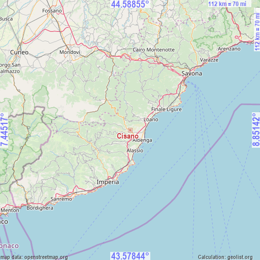
Cisano GPS coordinates[2]
44° 5' 8.34" North, 8° 8' 53.844" East
| Map corner | latitude | longitude |
|---|---|---|
| Upper-left | 44.58855°, | 7.44517° |
| Center: | 44.08565°, | 8.14829° |
| Lower-right: | 43.57844°, | 8.85142° |
| Map W x H: | 112.3×112.3 km | = 69.8×69.8mi |
| max Lat: | 47.04031° ⇑53.8% North |
| Cisano: | 44.08565° |
| min Lat: | ⇓46.2% South 35.50142° |
| min Long | Cisano | max Long |
| 6.69888° | 8.14829° | 18.48682° |
| W 8.3%⇐ | ⇒91.7% E |
Elevation
Elevation of Cisano is 54 m = 177 ft, and this is 252.7 m = 829 ft below average elevation for this country.
| Max E: |
2085 m = 6841 ft | 79% |
| Avg. | 306.7 m = 1006 ft | |
| Cisano | 54 m = 177 ft | |
Min E: |
-4 m = -13 ft | 21% |
See also: Italy elevation on elevation.city.
Geographical zone
Cisano is located in North temperate zone (between Tropic of Cancer and the Arctic Circle). Distance of this Northern Tropic circle is 2295.9 km =1426.6 mi to South.| Distance of | km | miles | from Cisano |
|---|---|---|---|
| North Pole | 5105.2 | 3172.2 | to North |
| Arctic Circle | 2499.3 | 1553 | to North |
| Tropic Cancer | 2295.9 | 1426.6 | to South |
| Equator | 4901.9 | 3045.9 | to South |


Nearby cities:
15 places around Cisano: (largest is in red/bold)
• Arnasco
3.4 km =2.1 mi,  255°
255°
• Balestrino
4.6 km =2.9 mi,  22°
22°
• Bastia
3.7 km =2.3 mi,  148°
148°
• Campochiesa
4.2 km =2.6 mi,  113°
113°
• Castelbianco
6.6 km =4.1 mi,  298°
298°
• Castelvecchio di Rocca Barbena
5.5 km =3.4 mi,  332°
332°
• Ceriale
6.5 km =4 mi,  84°
84°
• Chiesa
3.3 km =2.1 mi,  254°
254°
• Erli
6.7 km =4.2 mi, 328°
• Ortovero
5.3 km =3.3 mi,  227°
227°
• San Fedele-Lusignano
5.2 km =3.2 mi, 149°
• Toirano
6.6 km =4.1 mi,  45°
45°
• Vendone
6.2 km =3.9 mi, 261°
• Villanova d'Albenga
4.3 km =2.7 mi,  185°
185°
• Zuccarello
3.6 km =2.2 mi,  318°
318°
Sources, notices
• [Note1] Compared only with cities in Italy existing in our database
• [Src1] Map data: © OpenStreetMap contributors (CC-BY-SA)
• [Src2] Other city data from geonames.org with taken over terms of usage.
• [Src3] Geographical zone / Annual Mean Temperature by Robert A. Rohde @ Wikipedia
