Ceriale geodata
Ceriale (Liguria) is a seat of a third-order administrative division; located in Italy in Europe/Rome (GMT+2) time zone. With population of 5,152 people, there are 1897 cities with bigger population in this country. Compared to other cities in Italy, 53.8% of cities are located further ↑North; 90.8% of cities are located further →East and 94.8% of cities have higher elevation than Ceriale. Note1


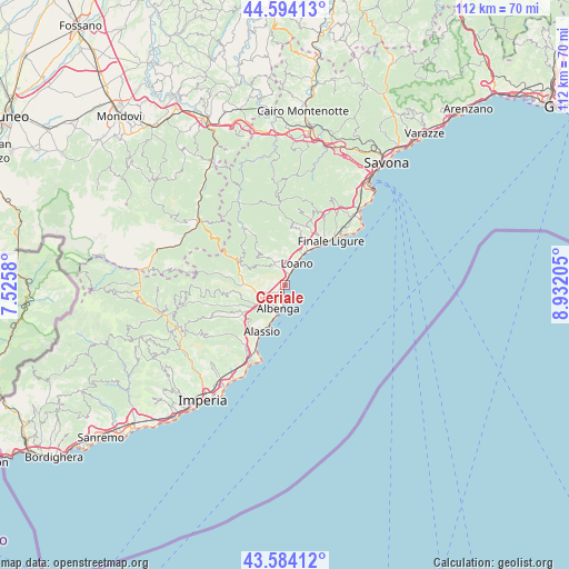
Ceriale GPS coordinates[2]
44° 5' 28.608" North, 8° 13' 44.148" East
| Map corner | latitude | longitude |
|---|---|---|
| Upper-left | 44.59413°, | 7.5258° |
| Center: | 44.09128°, | 8.22893° |
| Lower-right: | 43.58412°, | 8.93205° |
| Map W x H: | 112.3×112.3 km | = 69.8×69.8mi |
| max Lat: | 47.04031° ⇑53.8% North |
| Ceriale: | 44.09128° |
| min Lat: | ⇓46.2% South 35.50142° |
| min Long | Ceriale | max Long |
| 6.69888° | 8.22893° | 18.48682° |
| W 9.2%⇐ | ⇒90.8% E |
Elevation
Elevation of Ceriale is 9 m = 30 ft, and this is 297.7 m = 977 ft below average elevation for this country.
| Max E: |
2085 m = 6841 ft | 94.8% |
| Avg. | 306.7 m = 1006 ft | |
| Ceriale | 9 m = 30 ft | |
Min E: |
-4 m = -13 ft | 5.2% |
See also: Italy elevation on elevation.city.
Geographical zone
Ceriale is located in North temperate zone (between Tropic of Cancer and the Arctic Circle). Distance of this Northern Tropic circle is 2296.6 km =1427 mi to South.| Distance of | km | miles | from Ceriale |
|---|---|---|---|
| North Pole | 5104.6 | 3171.9 | to North |
| Arctic Circle | 2498.7 | 1552.6 | to North |
| Tropic Cancer | 2296.6 | 1427 | to South |
| Equator | 4902.5 | 3046.3 | to South |


Nearby cities:
15 places around Ceriale: (largest is in red/bold)
• Albenga
4.7 km =2.9 mi,  190°
190°
• Balestrino
5.9 km =3.7 mi,  308°
308°
• Bastia
5.9 km =3.7 mi,  230°
230°
• Boissano
5 km =3.1 mi,  353°
353°
• Borghetto Santo Spirito
2.5 km =1.6 mi,  23°
23°
• Campochiesa
3.4 km =2.1 mi, 227°
• Cisano
6.5 km =4 mi,  264°
264°
• Giustenice
9.1 km =5.7 mi,  7°
7°
• Loano
4.7 km =2.9 mi,  29°
29°
• Pietra Ligure
7.7 km =4.8 mi, 33°
• San Fedele-Lusignano
6.4 km =4 mi,  217°
217°
• San Lorenzo
9.2 km =5.7 mi, 7°
• Toirano
4.4 km =2.7 mi,  336°
336°
• Villanova d'Albenga
8.4 km =5.2 mi, 234°
• Zuccarello
9.1 km =5.7 mi,  283°
283°
Sources, notices
• [Note1] Compared only with cities in Italy existing in our database
• [Src1] Map data: © OpenStreetMap contributors (CC-BY-SA)
• [Src2] Other city data from geonames.org with taken over terms of usage.
• [Src3] Geographical zone / Annual Mean Temperature by Robert A. Rohde @ Wikipedia
