Castelbianco geodata
Castelbianco (Liguria) is a seat of a third-order administrative division; located in Italy in Europe/Rome (GMT+2) time zone. With population of 287 people, there are 10725 cities with bigger population in this country. Compared to other cities in Italy, 53.5% of cities are located further ↑North; 92.6% of cities are located further →East and 67.9% of cities have lower elevation than Castelbianco. Note1


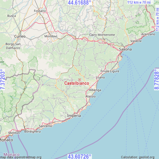
Castelbianco GPS coordinates[2]
44° 6' 51.228" North, 8° 4' 30.54" East
| Map corner | latitude | longitude |
|---|---|---|
| Upper-left | 44.61688°, | 7.37203° |
| Center: | 44.11423°, | 8.07515° |
| Lower-right: | 43.60726°, | 8.77828° |
| Map W x H: | 112.3×112.3 km | = 69.8×69.8mi |
| max Lat: | 47.04031° ⇑53.5% North |
| Castelbianco: | 44.11423° |
| min Lat: | ⇓46.5% South 35.50142° |
| min Long | Castelbianco | max Long |
| 6.69888° | 8.07515° | 18.48682° |
| W 7.4%⇐ | ⇒92.6% E |
Elevation
Elevation of Castelbianco is 373 m = 1224 ft, and this is 66.3 m = 218 ft above average elevation for this country.
| Max E: |
2085 m = 6841 ft | 32.1% |
| Castelbianco | 373 m 1224 ft | |
| Avg. | 306.7 m = 1006 ft | |
Min E: |
-4 m = -13 ft | 67.9% |
See also: Italy elevation on elevation.city.
Geographical zone
Castelbianco is located in North temperate zone (between Tropic of Cancer and the Arctic Circle). Distance of this Northern Tropic circle is 2299.1 km =1428.6 mi to South.| Distance of | km | miles | from Castelbianco |
|---|---|---|---|
| North Pole | 5102 | 3170.2 | to North |
| Arctic Circle | 2496.1 | 1551 | to North |
| Tropic Cancer | 2299.1 | 1428.6 | to South |
| Equator | 4905 | 3047.8 | to South |


Nearby cities:
15 places around Castelbianco: (largest is in red/bold)
• Alto
5.9 km =3.7 mi,  263°
263°
• Aquila di Arroscia
6.4 km =4 mi,  240°
240°
• Arnasco
4.8 km =3 mi,  147°
147°
• Balestrino
7.7 km =4.8 mi,  81°
81°
• Borgo di Ranzo
7.7 km =4.8 mi,  218°
218°
• Castelvecchio di Rocca Barbena
3.7 km =2.3 mi,  62°
62°
• Chiesa
4.9 km =3 mi, 146°
• Cisano
6.6 km =4.1 mi,  118°
118°
• Erli
3.5 km =2.2 mi,  42°
42°
• Garlenda
9.1 km =5.7 mi,  169°
169°
• Nasino-Borgo
3.4 km =2.1 mi,  268°
268°
• Onzo
5.2 km =3.2 mi,  200°
200°
• Ortovero
7 km =4.3 mi,  163°
163°
• Vendone
4.2 km =2.6 mi,  184°
184°
• Zuccarello
3.5 km =2.2 mi,  98°
98°
Sources, notices
• [Note1] Compared only with cities in Italy existing in our database
• [Src1] Map data: © OpenStreetMap contributors (CC-BY-SA)
• [Src2] Other city data from geonames.org with taken over terms of usage.
• [Src3] Geographical zone / Annual Mean Temperature by Robert A. Rohde @ Wikipedia
