Cisano Bergamasco geodata
Cisano Bergamasco (Lombardy) is a seat of a third-order administrative division; located in Italy in Europe/Rome (GMT+2) time zone. With population of 4,803 people, there are 2036 cities with bigger population in this country. Compared to other cities in Italy, 83.2% of cities are located further ↓South; 73.6% of cities are located further →East and 54.9% of cities have lower elevation than Cisano Bergamasco. Note1
Administrative division(s):
- Level 1: Lombardy
- Level 2: Provincia di Bergamo
- Level 3: Cisano Bergamasco


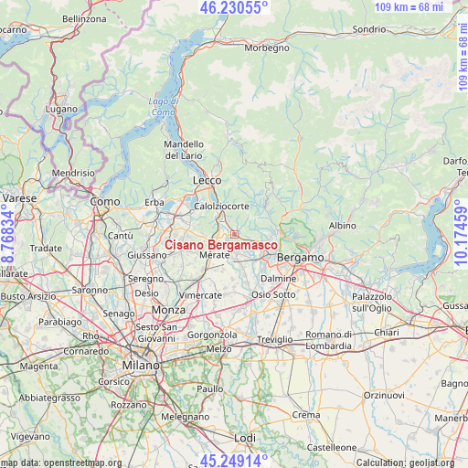
Cisano Bergamasco GPS coordinates[2]
45° 44' 31.2" North, 9° 28' 17.256" East
| Map corner | latitude | longitude |
|---|---|---|
| Upper-left | 46.23055°, | 8.76834° |
| Center: | 45.742°, | 9.47146° |
| Lower-right: | 45.24914°, | 10.17459° |
| Map W x H: | 109.1×109.1 km | = 67.8×67.8mi |
| max Lat: | 47.04031° ⇑16.8% North |
| Cisano Bergamasco: | 45.742° |
| min Lat: | ⇓83.2% South 35.50142° |
| min Long | Cisano Bergamas | max Long |
| 6.69888° | 9.47146° | 18.48682° |
| W 26.4%⇐ | ⇒73.6% E |
Elevation
Elevation of Cisano Bergamasco is 265 m = 869 ft, and this is 41.7 m = 137 ft below average elevation for this country.
| Max E: |
2085 m = 6841 ft | 45.1% |
| Avg. | 306.7 m = 1006 ft | |
| Cisano Bergamasco | 265 m = 869 ft | |
Min E: |
-4 m = -13 ft | 54.9% |
See also: Italy elevation on elevation.city.
Geographical zone
Cisano Bergamasco is located in North temperate zone (between Tropic of Cancer and the Arctic Circle). Distance of this North polar circle is 2315.1 km =1438.5 mi to North.| Distance of | km | miles | from Cisano Bergamasco |
|---|---|---|---|
| North Pole | 4921 | 3057.8 | to North |
| Arctic Circle | 2315.1 | 1438.5 | to North |
| Tropic Cancer | 2480.1 | 1541.1 | to South |
| Equator | 5086 | 3160.3 | to South |


Nearby cities:
15 places around Cisano Bergamasco: (largest is in red/bold)
• Airuno
3.6 km =2.2 mi,  290°
290°
• Arlate
3 km =1.9 mi,  227°
227°
• Brivio
2.3 km =1.4 mi,  256°
256°
• Caprino
1.8 km =1.1 mi,  64°
64°
• Carvico
4.6 km =2.9 mi,  165°
165°
• Cassina Fra Martino
4 km =2.5 mi, 227°
• Favirano
4.7 km =2.9 mi,  343°
343°
• Imbersago
4.5 km =2.8 mi,  207°
207°
• Monte Marenzo
3.6 km =2.2 mi, 338°
• Piazza Caduti
4.8 km =3 mi,  149°
149°
• Pontida
3.3 km =2.1 mi,  111°
111°
• Sant'Antonio
1.9 km =1.2 mi,  31°
31°
• Sotto il Monte Giovanni XXIII
4.7 km =2.9 mi, 148°
• Torre de' Busi
3.6 km =2.2 mi,  10°
10°
• Villa d'Adda
3.2 km =2 mi,  193°
193°
Sources, notices
• [Note1] Compared only with cities in Italy existing in our database
• [Src1] Map data: © OpenStreetMap contributors (CC-BY-SA)
• [Src2] Other city data from geonames.org with taken over terms of usage.
• [Src3] Geographical zone / Annual Mean Temperature by Robert A. Rohde @ Wikipedia
