Airuno geodata
Airuno (Lombardy) is a seat of a third-order administrative division; located in Italy in Europe/Rome (GMT+2) time zone. With population of 2,762 people, there are 3252 cities with bigger population in this country. Compared to other cities in Italy, 83.7% of cities are located further ↓South; 74.1% of cities are located further →East and 53.6% of cities have higher elevation than Airuno. Note1


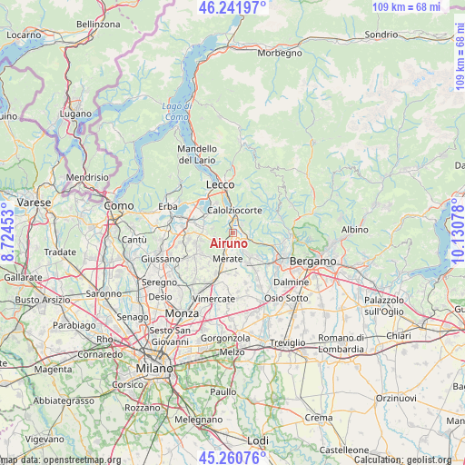
Airuno GPS coordinates[2]
45° 45' 12.672" North, 9° 25' 39.54" East
| Map corner | latitude | longitude |
|---|---|---|
| Upper-left | 46.24197°, | 8.72453° |
| Center: | 45.75352°, | 9.42765° |
| Lower-right: | 45.26076°, | 10.13078° |
| Map W x H: | 109.1×109.1 km | = 67.8×67.8mi |
| max Lat: | 47.04031° ⇑16.3% North |
| Airuno: | 45.75352° |
| min Lat: | ⇓83.7% South 35.50142° |
| min Long | Airuno | max Long |
| 6.69888° | 9.42765° | 18.48682° |
| W 25.9%⇐ | ⇒74.1% E |
Elevation
Elevation of Airuno is 212 m = 696 ft, and this is 94.7 m = 311 ft below average elevation for this country.
| Max E: |
2085 m = 6841 ft | 53.6% |
| Avg. | 306.7 m = 1006 ft | |
| Airuno | 212 m = 696 ft | |
Min E: |
-4 m = -13 ft | 46.4% |
See also: Italy elevation on elevation.city.
Geographical zone
Airuno is located in North temperate zone (between Tropic of Cancer and the Arctic Circle). Distance of this North polar circle is 2313.9 km =1437.8 mi to North.| Distance of | km | miles | from Airuno |
|---|---|---|---|
| North Pole | 4919.7 | 3057 | to North |
| Arctic Circle | 2313.9 | 1437.8 | to North |
| Tropic Cancer | 2481.4 | 1541.9 | to South |
| Equator | 5087.3 | 3161.1 | to South |


Nearby cities:
15 places around Airuno: (largest is in red/bold)
• Arlate
3.5 km =2.2 mi,  160°
160°
• Brivio
2.1 km =1.3 mi,  147°
147°
• Calco
3.5 km =2.2 mi,  199°
199°
• Calolziocorte
4.7 km =2.9 mi,  9°
9°
• Canova-San Zeno
4.2 km =2.6 mi,  210°
210°
• Cassina Fra Martino
4 km =2.5 mi,  174°
174°
• Cisano Bergamasco
3.6 km =2.2 mi,  110°
110°
• Favirano
3.8 km =2.4 mi,  33°
33°
• Monte Marenzo
3 km =1.9 mi,  45°
45°
• Monticello-Mondonico
3.3 km =2.1 mi,  232°
232°
• Olgiate Molgora
3.2 km =2 mi,  216°
216°
• Olginate
4.3 km =2.7 mi,  350°
350°
• Sant'Antonio
4.4 km =2.7 mi,  85°
85°
• Santa Maria Hoè
4.3 km =2.7 mi,  256°
256°
• Valgreghentino
3.1 km =1.9 mi,  338°
338°
Sources, notices
• [Note1] Compared only with cities in Italy existing in our database
• [Src1] Map data: © OpenStreetMap contributors (CC-BY-SA)
• [Src2] Other city data from geonames.org with taken over terms of usage.
• [Src3] Geographical zone / Annual Mean Temperature by Robert A. Rohde @ Wikipedia
