Cignano geodata
Cignano (Lombardy) is a populated place; located in Italy in Europe/Rome (GMT+2) time zone. With population of 600 people, there are 9006 cities with bigger population in this country. Compared to other cities in Italy, 69.5% of cities are located further ↓South; 66.8% of cities are located further →East and 75.9% of cities have higher elevation than Cignano. Note1


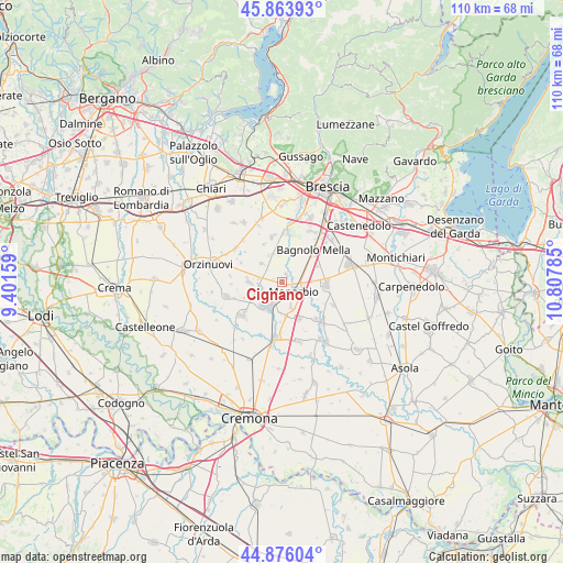
Cignano GPS coordinates[2]
45° 22' 19.704" North, 10° 6' 16.992" East
| Map corner | latitude | longitude |
|---|---|---|
| Upper-left | 45.86393°, | 9.40159° |
| Center: | 45.37214°, | 10.10472° |
| Lower-right: | 44.87604°, | 10.80785° |
| Map W x H: | 109.8×109.8 km | = 68.2×68.2mi |
| max Lat: | 47.04031° ⇑30.5% North |
| Cignano: | 45.37214° |
| min Lat: | ⇓69.5% South 35.50142° |
| min Long | Cignano | max Long |
| 6.69888° | 10.10472° | 18.48682° |
| W 33.2%⇐ | ⇒66.8% E |
Elevation
Elevation of Cignano is 70 m = 230 ft, and this is 236.7 m = 777 ft below average elevation for this country.
| Max E: |
2085 m = 6841 ft | 75.9% |
| Avg. | 306.7 m = 1006 ft | |
| Cignano | 70 m = 230 ft | |
Min E: |
-4 m = -13 ft | 24.1% |
See also: Italy elevation on elevation.city.
Geographical zone
Cignano is located in North temperate zone (between Tropic of Cancer and the Arctic Circle). Distance of this North polar circle is 2356.3 km =1464.1 mi to North.| Distance of | km | miles | from Cignano |
|---|---|---|---|
| North Pole | 4962.2 | 3083.4 | to North |
| Arctic Circle | 2356.3 | 1464.1 | to North |
| Tropic Cancer | 2439 | 1515.5 | to South |
| Equator | 5044.9 | 3134.8 | to South |


Nearby cities:
15 places around Cignano: (largest is in red/bold)
• Barbariga
5.4 km =3.4 mi,  312°
312°
• Bassano Bresciano
5.2 km =3.2 mi,  158°
158°
• Cadignano
3.9 km =2.4 mi,  251°
251°
• Corticelle Pieve
5.9 km =3.7 mi,  12°
12°
• Dello
5.7 km =3.5 mi,  336°
336°
• Manerbio
3.3 km =2.1 mi,  127°
127°
• Motella
8 km =5 mi, 247°
• Offlaga
1.8 km =1.1 mi,  34°
34°
• Porzano
7.8 km =4.8 mi,  65°
65°
• Quinzanello
5.3 km =3.3 mi,  354°
354°
• San Gervasio Bresciano
7.9 km =4.9 mi, 155°
• San Paolo
6.3 km =3.9 mi,  270°
270°
• Scarpizzolo
4.4 km =2.7 mi,  277°
277°
• Verolanuova
5.3 km =3.3 mi,  202°
202°
• Verolavecchia
6.2 km =3.9 mi,  218°
218°
Sources, notices
• [Note1] Compared only with cities in Italy existing in our database
• [Src1] Map data: © OpenStreetMap contributors (CC-BY-SA)
• [Src2] Other city data from geonames.org with taken over terms of usage.
• [Src3] Geographical zone / Annual Mean Temperature by Robert A. Rohde @ Wikipedia
