Barbariga geodata
Barbariga (Lombardy) is a seat of a third-order administrative division; located in Italy in Europe/Rome (GMT+2) time zone. With population of 1,796 people, there are 4495 cities with bigger population in this country. Compared to other cities in Italy, 70.4% of cities are located further ↓South; 67.3% of cities are located further →East and 73.6% of cities have higher elevation than Barbariga. Note1


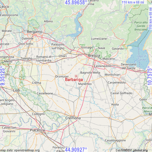
Barbariga GPS coordinates[2]
45° 24' 18.288" North, 10° 3' 15.732" East
| Map corner | latitude | longitude |
|---|---|---|
| Upper-left | 45.89658°, | 9.35125° |
| Center: | 45.40508°, | 10.05437° |
| Lower-right: | 44.90927°, | 10.7575° |
| Map W x H: | 109.8×109.8 km | = 68.2×68.2mi |
| max Lat: | 47.04031° ⇑29.6% North |
| Barbariga: | 45.40508° |
| min Lat: | ⇓70.4% South 35.50142° |
| min Long | Barbariga | max Long |
| 6.69888° | 10.05437° | 18.48682° |
| W 32.7%⇐ | ⇒67.3% E |
Elevation
Elevation of Barbariga is 80 m = 262 ft, and this is 226.7 m = 744 ft below average elevation for this country.
| Max E: |
2085 m = 6841 ft | 73.6% |
| Avg. | 306.7 m = 1006 ft | |
| Barbariga | 80 m = 262 ft | |
Min E: |
-4 m = -13 ft | 26.4% |
See also: Italy elevation on elevation.city.
Geographical zone
Barbariga is located in North temperate zone (between Tropic of Cancer and the Arctic Circle). Distance of this North polar circle is 2352.6 km =1461.8 mi to North.| Distance of | km | miles | from Barbariga |
|---|---|---|---|
| North Pole | 4958.5 | 3081.1 | to North |
| Arctic Circle | 2352.6 | 1461.8 | to North |
| Tropic Cancer | 2442.7 | 1517.8 | to South |
| Equator | 5048.6 | 3137.1 | to South |


Nearby cities:
15 places around Barbariga: (largest is in red/bold)
• Bargnano
3.1 km =1.9 mi,  336°
336°
• Brandico
5.5 km =3.4 mi,  358°
358°
• Cadignano
4.9 km =3 mi,  176°
176°
• Cignano
5.4 km =3.4 mi,  132°
132°
• Coniolo
6.6 km =4.1 mi,  248°
248°
• Corticelle Pieve
5.6 km =3.5 mi,  68°
68°
• Corzano
5.7 km =3.5 mi,  319°
319°
• Dello
2.3 km =1.4 mi,  47°
47°
• Longhena
3.6 km =2.2 mi,  6°
6°
• Mairano
5.2 km =3.2 mi,  22°
22°
• Offlaga
5.4 km =3.4 mi,  114°
114°
• Pompiano
5.9 km =3.7 mi,  299°
299°
• Quinzanello
3.7 km =2.3 mi, 65°
• San Paolo
4.3 km =2.7 mi,  213°
213°
• Scarpizzolo
3.1 km =1.9 mi,  187°
187°
Sources, notices
• [Note1] Compared only with cities in Italy existing in our database
• [Src1] Map data: © OpenStreetMap contributors (CC-BY-SA)
• [Src2] Other city data from geonames.org with taken over terms of usage.
• [Src3] Geographical zone / Annual Mean Temperature by Robert A. Rohde @ Wikipedia
