Ciampino geodata
Ciampino (Latium) is a seat of a third-order administrative division; located in Italy in Europe/Rome (GMT+2) time zone. With population of 35,174 people, there are 213 cities with bigger population in this country. Compared to other cities in Italy, 72% of cities are located further ↑North; 63.6% of cities are located further ←West and 65.1% of cities have higher elevation than Ciampino. Note1
Administrative division(s):
- Level 1: Latium
- Level 2: Città metropolitana di Roma Capitale
- Level 3: Ciampino


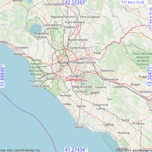
Ciampino GPS coordinates[2]
41° 48' 2.304" North, 12° 36' 5.688" East
| Map corner | latitude | longitude |
|---|---|---|
| Upper-left | 42.32265°, | 11.89846° |
| Center: | 41.80064°, | 12.60158° |
| Lower-right: | 41.27434°, | 13.30471° |
| Map W x H: | 116.6×116.6 km | = 72.5×72.5mi |
| max Lat: | 47.04031° ⇑72% North |
| Ciampino: | 41.80064° |
| min Lat: | ⇓28% South 35.50142° |
| min Long | Ciampino | max Long |
| 6.69888° | 12.60158° | 18.48682° |
| W 63.6%⇐ | ⇒36.4% E |
Elevation
Elevation of Ciampino is 127 m = 417 ft, and this is 179.7 m = 590 ft below average elevation for this country.
| Max E: |
2085 m = 6841 ft | 65.1% |
| Avg. | 306.7 m = 1006 ft | |
| Ciampino | 127 m = 417 ft | |
Min E: |
-4 m = -13 ft | 34.9% |
See also: Italy elevation on elevation.city.
Geographical zone
Ciampino is located in North temperate zone (between Tropic of Cancer and the Arctic Circle). Distance of this Northern Tropic circle is 2041.9 km =1268.8 mi to South.| Distance of | km | miles | from Ciampino |
|---|---|---|---|
| North Pole | 5359.3 | 3330.1 | to North |
| Arctic Circle | 2753.4 | 1710.9 | to North |
| Tropic Cancer | 2041.9 | 1268.8 | to South |
| Equator | 4647.8 | 2888 | to South |


Nearby cities:
15 places around Ciampino: (largest is in red/bold)
• Albano Laziale
9.4 km =5.8 mi,  149°
149°
• Ariccia
10.7 km =6.6 mi, 146°
• Armetta
7.3 km =4.5 mi,  79°
79°
• Borgo Lotti
5.6 km =3.5 mi,  223°
223°
• Cancelliera-Massimetta-Pantanelle
10.9 km =6.8 mi,  176°
176°
• Castel Gandolfo
7 km =4.3 mi, 145°
• Castel di Leva
5.3 km =3.3 mi,  239°
239°
• Frascati
6.5 km =4 mi, 81°
• Grottaferrata
6 km =3.7 mi,  105°
105°
• Marino
5.9 km =3.7 mi,  125°
125°
• Monte Porzio Catone
9.5 km =5.9 mi, 79°
• Pavona
8.4 km =5.2 mi,  171°
171°
• Rocca di Papa
9.2 km =5.7 mi, 114°
• Spregamore
8.3 km =5.2 mi,  209°
209°
• Stazione di Pavona-Palazzo Margana
9.1 km =5.7 mi,  185°
185°
Sources, notices
• [Note1] Compared only with cities in Italy existing in our database
• [Src1] Map data: © OpenStreetMap contributors (CC-BY-SA)
• [Src2] Other city data from geonames.org with taken over terms of usage.
• [Src3] Geographical zone / Annual Mean Temperature by Robert A. Rohde @ Wikipedia
