Castel di Leva geodata
Castel di Leva (Latium) is a populated place; located in Italy in Europe/Rome (GMT+2) time zone. With population of 570 people, there are 9260 cities with bigger population in this country. Compared to other cities in Italy, 72.2% of cities are located further ↑North; 62.9% of cities are located further ←West and 70.9% of cities have higher elevation than Castel di Leva. Note1
Administrative division(s):
- Level 1: Latium
- Level 2: Città metropolitana di Roma Capitale
- Level 3: Roma Capitale
- Level 4: Municipio Roma IX


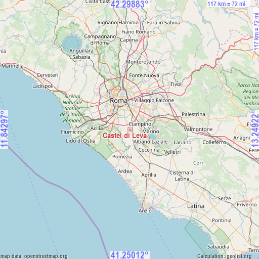
Castel di Leva GPS coordinates[2]
41° 46' 35.832" North, 12° 32' 45.924" East
| Map corner | latitude | longitude |
|---|---|---|
| Upper-left | 42.29883°, | 11.84297° |
| Center: | 41.77662°, | 12.54609° |
| Lower-right: | 41.25012°, | 13.24922° |
| Map W x H: | 116.6×116.6 km | = 72.5×72.5mi |
| max Lat: | 47.04031° ⇑72.2% North |
| Castel di Leva: | 41.77662° |
| min Lat: | ⇓27.8% South 35.50142° |
| min Long | Castel di Leva | max Long |
| 6.69888° | 12.54609° | 18.48682° |
| W 62.9%⇐ | ⇒37.1% E |
Elevation
Elevation of Castel di Leva is 93 m = 305 ft, and this is 213.7 m = 701 ft below average elevation for this country.
| Max E: |
2085 m = 6841 ft | 70.9% |
| Avg. | 306.7 m = 1006 ft | |
| Castel di Leva | 93 m = 305 ft | |
Min E: |
-4 m = -13 ft | 29.1% |
See also: Italy elevation on elevation.city.
Geographical zone
Castel di Leva is located in North temperate zone (between Tropic of Cancer and the Arctic Circle). Distance of this Northern Tropic circle is 2039.2 km =1267.1 mi to South.| Distance of | km | miles | from Castel di Leva |
|---|---|---|---|
| North Pole | 5361.9 | 3331.7 | to North |
| Arctic Circle | 2756 | 1712.5 | to North |
| Tropic Cancer | 2039.2 | 1267.1 | to South |
| Equator | 4645.1 | 2886.3 | to South |


Nearby cities:
15 places around Castel di Leva: (largest is in red/bold)
• Albano Laziale
10.8 km =6.7 mi,  120°
120°
• Area Produttiva
11 km =6.8 mi,  197°
197°
• Borgo Lotti
1.6 km =1 mi,  151°
151°
• Cancelliera-Massimetta-Pantanelle
9.8 km =6.1 mi, 147°
• Castel Gandolfo
9.1 km =5.7 mi,  109°
109°
• Ciampino
5.3 km =3.3 mi,  59°
59°
• Colle del Pino
5.6 km =3.5 mi,  227°
227°
• Grottaferrata
10.5 km =6.5 mi,  83°
83°
• Marino
9.4 km =5.8 mi,  94°
94°
• Monte Migliore La Selvotta
7.2 km =4.5 mi,  210°
210°
• Pavona
8.1 km =5 mi,  133°
133°
• Santa Palomba-Roma II
8.4 km =5.2 mi,  165°
165°
• Selcetta
6 km =3.7 mi,  257°
257°
• Spregamore
4.5 km =2.8 mi, 174°
• Stazione di Pavona-Palazzo Margana
7.4 km =4.6 mi, 150°
Sources, notices
• [Note1] Compared only with cities in Italy existing in our database
• [Src1] Map data: © OpenStreetMap contributors (CC-BY-SA)
• [Src2] Other city data from geonames.org with taken over terms of usage.
• [Src3] Geographical zone / Annual Mean Temperature by Robert A. Rohde @ Wikipedia
