Chiavari geodata
Chiavari (Liguria) is a seat of a third-order administrative division; located in Italy in Europe/Rome (GMT+2) time zone. With population of 26,572 people, there are 304 cities with bigger population in this country. Compared to other cities in Italy, 51.7% of cities are located further ↑North; 76% of cities are located further →East and 95.9% of cities have higher elevation than Chiavari. Note1


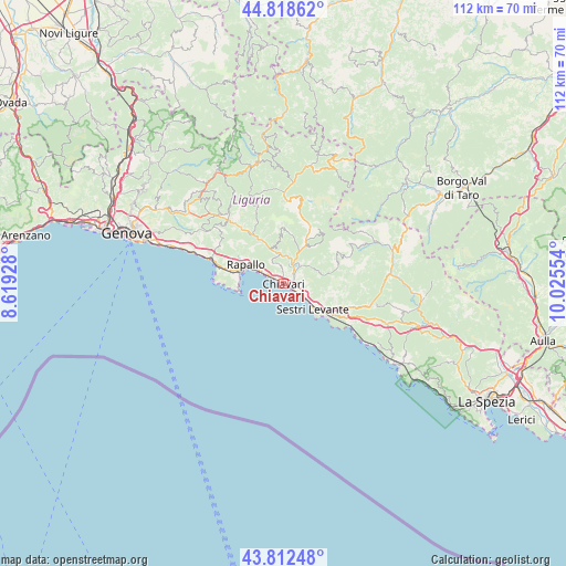
Chiavari GPS coordinates[2]
44° 19' 3.756" North, 9° 19' 20.676" East
| Map corner | latitude | longitude |
|---|---|---|
| Upper-left | 44.81862°, | 8.61928° |
| Center: | 44.31771°, | 9.32241° |
| Lower-right: | 43.81248°, | 10.02554° |
| Map W x H: | 111.9×111.9 km | = 69.5×69.5mi |
| max Lat: | 47.04031° ⇑51.7% North |
| Chiavari: | 44.31771° |
| min Lat: | ⇓48.3% South 35.50142° |
| min Long | Chiavari | max Long |
| 6.69888° | 9.32241° | 18.48682° |
| W 24%⇐ | ⇒76% E |
Elevation
Elevation of Chiavari is 7 m = 23 ft, and this is 299.7 m = 983 ft below average elevation for this country.
| Max E: |
2085 m = 6841 ft | 95.9% |
| Avg. | 306.7 m = 1006 ft | |
| Chiavari | 7 m = 23 ft | |
Min E: |
-4 m = -13 ft | 4.1% |
See also: Italy elevation on elevation.city.
Geographical zone
Chiavari is located in North temperate zone (between Tropic of Cancer and the Arctic Circle). Distance of this Northern Tropic circle is 2321.7 km =1442.6 mi to South.| Distance of | km | miles | from Chiavari |
|---|---|---|---|
| North Pole | 5079.4 | 3156.2 | to North |
| Arctic Circle | 2473.5 | 1537 | to North |
| Tropic Cancer | 2321.7 | 1442.6 | to South |
| Equator | 4927.7 | 3061.9 | to South |


Nearby cities:
15 places around Chiavari: (largest is in red/bold)
• Bocco
4 km =2.5 mi,  337°
337°
• Carasco
4 km =2.5 mi,  27°
27°
• Chiesa Nuova
5.9 km =3.7 mi,  351°
351°
• Cogorno
3.9 km =2.4 mi,  85°
85°
• Conscenti
6.5 km =4 mi,  62°
62°
• Lavagna
2.8 km =1.7 mi,  117°
117°
• Leivi
4.1 km =2.5 mi, 346°
• Mezzanego
8.4 km =5.2 mi, 30°
• Prati
8.4 km =5.2 mi, 30°
• Rapallo
8.3 km =5.2 mi,  295°
295°
• Rivarola
3.9 km =2.4 mi,  42°
42°
• San Salvatore
3 km =1.9 mi, 60°
• Santa Margherita Ligure
9 km =5.6 mi,  282°
282°
• Sestri Levante
7.7 km =4.8 mi,  129°
129°
• Zoagli
4.9 km =3 mi, 295°
Sources, notices
• [Note1] Compared only with cities in Italy existing in our database
• [Src1] Map data: © OpenStreetMap contributors (CC-BY-SA)
• [Src2] Other city data from geonames.org with taken over terms of usage.
• [Src3] Geographical zone / Annual Mean Temperature by Robert A. Rohde @ Wikipedia
