Rivarola geodata
Rivarola (Liguria) is a populated place; located in Italy in Europe/Rome (GMT+2) time zone. With population of 778 people, there are 7773 cities with bigger population in this country. Compared to other cities in Italy, 51.3% of cities are located further ↑North; 75.4% of cities are located further →East and 92.1% of cities have higher elevation than Rivarola. Note1


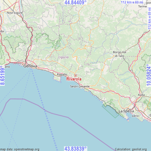
Rivarola GPS coordinates[2]
44° 20' 36.24" North, 9° 21' 18.396" East
| Map corner | latitude | longitude |
|---|---|---|
| Upper-left | 44.84409°, | 8.65199° |
| Center: | 44.3434°, | 9.35511° |
| Lower-right: | 43.83839°, | 10.05824° |
| Map W x H: | 111.8×111.8 km | = 69.5×69.5mi |
| max Lat: | 47.04031° ⇑51.3% North |
| Rivarola: | 44.3434° |
| min Lat: | ⇓48.7% South 35.50142° |
| min Long | Rivarola | max Long |
| 6.69888° | 9.35511° | 18.48682° |
| W 24.6%⇐ | ⇒75.4% E |
Elevation
Elevation of Rivarola is 14 m = 46 ft, and this is 292.7 m = 960 ft below average elevation for this country.
| Max E: |
2085 m = 6841 ft | 92.1% |
| Avg. | 306.7 m = 1006 ft | |
| Rivarola | 14 m = 46 ft | |
Min E: |
-4 m = -13 ft | 7.9% |
See also: Italy elevation on elevation.city.
Geographical zone
Rivarola is located in North temperate zone (between Tropic of Cancer and the Arctic Circle). Distance of this Northern Tropic circle is 2324.6 km =1444.4 mi to South.| Distance of | km | miles | from Rivarola |
|---|---|---|---|
| North Pole | 5076.5 | 3154.4 | to North |
| Arctic Circle | 2470.7 | 1535.2 | to North |
| Tropic Cancer | 2324.6 | 1444.4 | to South |
| Equator | 4930.5 | 3063.7 | to South |


Nearby cities:
15 places around Rivarola: (largest is in red/bold)
• Bocco
4.2 km =2.6 mi,  281°
281°
• Borzonasca
8.9 km =5.5 mi,  17°
17°
• Carasco
1 km =0.6 mi,  313°
313°
• Chiavari
3.9 km =2.4 mi,  222°
222°
• Chiesa Nuova
4.5 km =2.8 mi, 310°
• Cogorno
2.8 km =1.7 mi,  153°
153°
• Conscenti
3.2 km =2 mi,  86°
86°
• Coreglia Ligure
9 km =5.6 mi,  303°
303°
• Lavagna
4.1 km =2.5 mi,  181°
181°
• Leivi
3.7 km =2.3 mi,  287°
287°
• Mezzanego
4.7 km =2.9 mi, 21°
• Prati
4.7 km =2.9 mi, 20°
• San Salvatore
1.4 km =0.9 mi, 181°
• Sestri Levante
8.5 km =5.3 mi,  156°
156°
• Zoagli
7.1 km =4.4 mi,  263°
263°
Sources, notices
• [Note1] Compared only with cities in Italy existing in our database
• [Src1] Map data: © OpenStreetMap contributors (CC-BY-SA)
• [Src2] Other city data from geonames.org with taken over terms of usage.
• [Src3] Geographical zone / Annual Mean Temperature by Robert A. Rohde @ Wikipedia
