San Salvatore geodata
San Salvatore (Liguria) is a populated place; located in Italy in Europe/Rome (GMT+2) time zone. With population of 4,172 people, there are 2302 cities with bigger population in this country. Compared to other cities in Italy, 51.5% of cities are located further ↑North; 75.4% of cities are located further →East and 92.1% of cities have higher elevation than San Salvatore. Note1


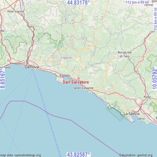
San Salvatore GPS coordinates[2]
44° 19' 51.528" North, 9° 21' 17.244" East
| Map corner | latitude | longitude |
|---|---|---|
| Upper-left | 44.83178°, | 8.65167° |
| Center: | 44.33098°, | 9.35479° |
| Lower-right: | 43.82587°, | 10.05792° |
| Map W x H: | 111.8×111.8 km | = 69.5×69.5mi |
| max Lat: | 47.04031° ⇑51.5% North |
| San Salvatore: | 44.33098° |
| min Lat: | ⇓48.5% South 35.50142° |
| min Long | San Salvatore | max Long |
| 6.69888° | 9.35479° | 18.48682° |
| W 24.6%⇐ | ⇒75.4% E |
Elevation
Elevation of San Salvatore is 14 m = 46 ft, and this is 292.7 m = 960 ft below average elevation for this country.
| Max E: |
2085 m = 6841 ft | 92.1% |
| Avg. | 306.7 m = 1006 ft | |
| San Salvatore | 14 m = 46 ft | |
Min E: |
-4 m = -13 ft | 7.9% |
See also: Italy elevation on elevation.city.
Geographical zone
San Salvatore is located in North temperate zone (between Tropic of Cancer and the Arctic Circle). Distance of this Northern Tropic circle is 2323.2 km =1443.6 mi to South.| Distance of | km | miles | from San Salvatore |
|---|---|---|---|
| North Pole | 5077.9 | 3155.3 | to North |
| Arctic Circle | 2472 | 1536 | to North |
| Tropic Cancer | 2323.2 | 1443.6 | to South |
| Equator | 4929.1 | 3062.8 | to South |


Nearby cities:
15 places around San Salvatore: (largest is in red/bold)
• Bocco
4.7 km =2.9 mi,  298°
298°
• Carasco
2.2 km =1.4 mi,  340°
340°
• Casarza Ligure
9.9 km =6.2 mi,  131°
131°
• Chiavari
3 km =1.9 mi,  240°
240°
• Chiesa Nuova
5.5 km =3.4 mi,  321°
321°
• Cogorno
1.7 km =1.1 mi, 131°
• Conscenti
3.6 km =2.2 mi,  64°
64°
• Coreglia Ligure
9.8 km =6.1 mi,  310°
310°
• Lavagna
2.8 km =1.7 mi,  181°
181°
• Leivi
4.3 km =2.7 mi, 305°
• Mezzanego
6 km =3.7 mi,  16°
16°
• Prati
6 km =3.7 mi, 16°
• Rivarola
1.4 km =0.9 mi,  1°
1°
• Sestri Levante
7.2 km =4.5 mi,  152°
152°
• Zoagli
7 km =4.3 mi,  275°
275°
Sources, notices
• [Note1] Compared only with cities in Italy existing in our database
• [Src1] Map data: © OpenStreetMap contributors (CC-BY-SA)
• [Src2] Other city data from geonames.org with taken over terms of usage.
• [Src3] Geographical zone / Annual Mean Temperature by Robert A. Rohde @ Wikipedia
