Cesenatico geodata
Cesenatico (Emilia-Romagna) is a seat of a third-order administrative division; located in Italy in Europe/Rome (GMT+2) time zone. With population of 18,925 people, there are 464 cities with bigger population in this country. Compared to other cities in Italy, 52.8% of cities are located further ↑North; 61.3% of cities are located further ←West and 98.4% of cities have higher elevation than Cesenatico. Note1
Administrative division(s):
- Level 1: Emilia-Romagna
- Level 2: Provincia di Forlì-Cesena
- Level 3: Cesenatico


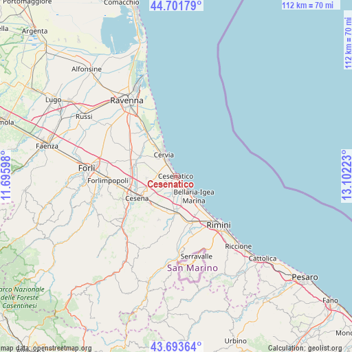
Cesenatico GPS coordinates[2]
44° 11' 59.532" North, 12° 23' 56.76" East
| Map corner | latitude | longitude |
|---|---|---|
| Upper-left | 44.70179°, | 11.69598° |
| Center: | 44.19987°, | 12.3991° |
| Lower-right: | 43.69364°, | 13.10223° |
| Map W x H: | 112.1×112.1 km | = 69.7×69.7mi |
| max Lat: | 47.04031° ⇑52.8% North |
| Cesenatico: | 44.19987° |
| min Lat: | ⇓47.2% South 35.50142° |
| min Long | Cesenatico | max Long |
| 6.69888° | 12.3991° | 18.48682° |
| W 61.3%⇐ | ⇒38.7% E |
Elevation
Elevation of Cesenatico is 3 m = 10 ft, and this is 303.7 m = 996 ft below average elevation for this country.
| Max E: |
2085 m = 6841 ft | 98.4% |
| Avg. | 306.7 m = 1006 ft | |
| Cesenatico | 3 m = 10 ft | |
Min E: |
-4 m = -13 ft | 1.6% |
See also: Italy elevation on elevation.city.
Geographical zone
Cesenatico is located in North temperate zone (between Tropic of Cancer and the Arctic Circle). Distance of this Northern Tropic circle is 2308.6 km =1434.5 mi to South.| Distance of | km | miles | from Cesenatico |
|---|---|---|---|
| North Pole | 5092.5 | 3164.3 | to North |
| Arctic Circle | 2486.6 | 1545.1 | to North |
| Tropic Cancer | 2308.6 | 1434.5 | to South |
| Equator | 4914.6 | 3053.8 | to South |


Nearby cities:
15 places around Cesenatico: (largest is in red/bold)
• Bagnarola
6.1 km =3.8 mi,  227°
227°
• Bellaria-Igea Marina
8.6 km =5.3 mi,  137°
137°
• Budrio
12.1 km =7.5 mi,  202°
202°
• Capanni
5.3 km =3.3 mi,  152°
152°
• Cervia
8 km =5 mi,  329°
329°
• Gambettola
10.4 km =6.5 mi,  208°
208°
• Gatteo a Mare
4.4 km =2.7 mi, 138°
• Gatteo-Sant'Angelo
9.8 km =6.1 mi,  183°
183°
• Milano Marittima
9.1 km =5.7 mi,  335°
335°
• Pinarella
5.2 km =3.2 mi, 334°
• Pisignano
11.2 km =7 mi,  292°
292°
• Sala
5 km =3.1 mi,  194°
194°
• San Mauro Pascoli
10.2 km =6.3 mi,  170°
170°
• San Mauro a Mare
5.5 km =3.4 mi, 136°
• Villa Inferno
7.3 km =4.5 mi,  298°
298°
Sources, notices
• [Note1] Compared only with cities in Italy existing in our database
• [Src1] Map data: © OpenStreetMap contributors (CC-BY-SA)
• [Src2] Other city data from geonames.org with taken over terms of usage.
• [Src3] Geographical zone / Annual Mean Temperature by Robert A. Rohde @ Wikipedia
