Cervo geodata
Cervo (Liguria) is a seat of a third-order administrative division; located in Italy in Europe/Rome (GMT+2) time zone. With population of 1,021 people, there are 6577 cities with bigger population in this country. Compared to other cities in Italy, 55.4% of cities are located further ↑North; 92% of cities are located further →East and 77.7% of cities have higher elevation than Cervo. Note1


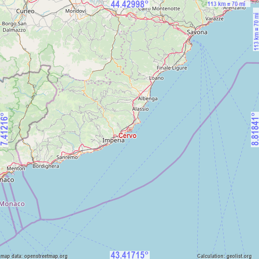
Cervo GPS coordinates[2]
43° 55' 32.592" North, 8° 6' 55.044" East
| Map corner | latitude | longitude |
|---|---|---|
| Upper-left | 44.42998°, | 7.41216° |
| Center: | 43.92572°, | 8.11529° |
| Lower-right: | 43.41715°, | 8.81841° |
| Map W x H: | 112.6×112.6 km | = 70×70mi |
| max Lat: | 47.04031° ⇑55.4% North |
| Cervo: | 43.92572° |
| min Lat: | ⇓44.6% South 35.50142° |
| min Long | Cervo | max Long |
| 6.69888° | 8.11529° | 18.48682° |
| W 8%⇐ | ⇒92% E |
Elevation
Elevation of Cervo is 61 m = 200 ft, and this is 245.7 m = 806 ft below average elevation for this country.
| Max E: |
2085 m = 6841 ft | 77.7% |
| Avg. | 306.7 m = 1006 ft | |
| Cervo | 61 m = 200 ft | |
Min E: |
-4 m = -13 ft | 22.3% |
See also: Italy elevation on elevation.city.
Geographical zone
Cervo is located in North temperate zone (between Tropic of Cancer and the Arctic Circle). Distance of this Northern Tropic circle is 2278.2 km =1415.6 mi to South.| Distance of | km | miles | from Cervo |
|---|---|---|---|
| North Pole | 5123 | 3183.3 | to North |
| Arctic Circle | 2517.1 | 1564.1 | to North |
| Tropic Cancer | 2278.2 | 1415.6 | to South |
| Equator | 4884.1 | 3034.8 | to South |


Nearby cities:
15 places around Cervo: (largest is in red/bold)
• Andora
3.9 km =2.4 mi,  32°
32°
• Borgo Sant'Agata
8.8 km =5.5 mi,  253°
253°
• Diano Arentino
6.5 km =4 mi,  294°
294°
• Diano Castello
3.9 km =2.4 mi,  267°
267°
• Diano Marina
3.3 km =2.1 mi,  239°
239°
• Diano San Pietro
3.5 km =2.2 mi,  277°
277°
• Imperia
7.3 km =4.5 mi, 236°
• Laigueglia
6.6 km =4.1 mi, 31°
• Marina di Andora
4.4 km =2.7 mi,  45°
45°
• Molino Nuovo
6.4 km =4 mi,  10°
10°
• Pian Rosso-Costa
7.4 km =4.6 mi,  2°
2°
• Pontedassio
8.2 km =5.1 mi, 279°
• San Bartolomeo al Mare
0.9 km =0.6 mi, 250°
• Stellanello
9.4 km =5.8 mi,  331°
331°
• Villa Faraldi
5.2 km =3.2 mi,  336°
336°
Sources, notices
• [Note1] Compared only with cities in Italy existing in our database
• [Src1] Map data: © OpenStreetMap contributors (CC-BY-SA)
• [Src2] Other city data from geonames.org with taken over terms of usage.
• [Src3] Geographical zone / Annual Mean Temperature by Robert A. Rohde @ Wikipedia
