Andora geodata
Andora (Liguria) is a seat of a third-order administrative division; located in Italy in Europe/Rome (GMT+2) time zone. With population of 6,767 people, there are 1451 cities with bigger population in this country. Compared to other cities in Italy, 55.2% of cities are located further ↑North; 91.7% of cities are located further →East and 95.9% of cities have higher elevation than Andora. Note1


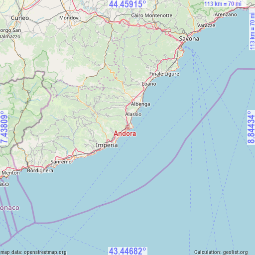
Andora GPS coordinates[2]
43° 57' 18.504" North, 8° 8' 28.356" East
| Map corner | latitude | longitude |
|---|---|---|
| Upper-left | 44.45915°, | 7.43809° |
| Center: | 43.95514°, | 8.14121° |
| Lower-right: | 43.44682°, | 8.84434° |
| Map W x H: | 112.6×112.6 km | = 70×70mi |
| max Lat: | 47.04031° ⇑55.2% North |
| Andora: | 43.95514° |
| min Lat: | ⇓44.8% South 35.50142° |
| min Long | Andora | max Long |
| 6.69888° | 8.14121° | 18.48682° |
| W 8.3%⇐ | ⇒91.7% E |
Elevation
Elevation of Andora is 7 m = 23 ft, and this is 299.7 m = 983 ft below average elevation for this country.
| Max E: |
2085 m = 6841 ft | 95.9% |
| Avg. | 306.7 m = 1006 ft | |
| Andora | 7 m = 23 ft | |
Min E: |
-4 m = -13 ft | 4.1% |
See also: Italy elevation on elevation.city.
Geographical zone
Andora is located in North temperate zone (between Tropic of Cancer and the Arctic Circle). Distance of this Northern Tropic circle is 2281.4 km =1417.6 mi to South.| Distance of | km | miles | from Andora |
|---|---|---|---|
| North Pole | 5119.7 | 3181.2 | to North |
| Arctic Circle | 2513.8 | 1562 | to North |
| Tropic Cancer | 2281.4 | 1417.6 | to South |
| Equator | 4887.4 | 3036.9 | to South |


Nearby cities:
15 places around Andora: (largest is in red/bold)
• Alassio
5.8 km =3.6 mi,  20°
20°
• Cervo
3.9 km =2.4 mi,  212°
212°
• Diano Arentino
8 km =5 mi,  265°
265°
• Diano Castello
6.9 km =4.3 mi,  240°
240°
• Diano Marina
6.9 km =4.3 mi,  224°
224°
• Diano San Pietro
6.2 km =3.9 mi, 242°
• Laigueglia
2.7 km =1.7 mi,  30°
30°
• Marina di Andora
1.1 km =0.7 mi,  99°
99°
• Molino Nuovo
3.1 km =1.9 mi,  343°
343°
• Pian Rosso-Costa
4.5 km =2.8 mi, 337°
• Rossi
8.3 km =5.2 mi,  307°
307°
• San Bartolomeo al Mare
4.6 km =2.9 mi, 219°
• Stellanello
8.2 km =5.1 mi, 307°
• Villa Faraldi
4.4 km =2.7 mi,  289°
289°
• Villafranca
9.1 km =5.7 mi, 341°
Sources, notices
• [Note1] Compared only with cities in Italy existing in our database
• [Src1] Map data: © OpenStreetMap contributors (CC-BY-SA)
• [Src2] Other city data from geonames.org with taken over terms of usage.
• [Src3] Geographical zone / Annual Mean Temperature by Robert A. Rohde @ Wikipedia
