Imperia geodata
Imperia (Liguria) is a seat of a second-order administrative division; located in Italy in Europe/Rome (GMT+2) time zone. With population of 38,675 people, there are 188 cities with bigger population in this country. Compared to other cities in Italy, 55.9% of cities are located further ↑North; 93.1% of cities are located further →East and 94.8% of cities have higher elevation than Imperia. Note1


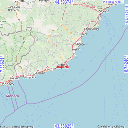
Imperia GPS coordinates[2]
43° 53' 21.012" North, 8° 2' 21.588" East
| Map corner | latitude | longitude |
|---|---|---|
| Upper-left | 44.39374°, | 7.33621° |
| Center: | 43.88917°, | 8.03933° |
| Lower-right: | 43.38029°, | 8.74246° |
| Map W x H: | 112.7×112.7 km | = 70×70mi |
| max Lat: | 47.04031° ⇑55.9% North |
| Imperia: | 43.88917° |
| min Lat: | ⇓44.1% South 35.50142° |
| min Long | Imperia | max Long |
| 6.69888° | 8.03933° | 18.48682° |
| W 6.9%⇐ | ⇒93.1% E |
Elevation
Elevation of Imperia is 9 m = 30 ft, and this is 297.7 m = 977 ft below average elevation for this country.
| Max E: |
2085 m = 6841 ft | 94.8% |
| Avg. | 306.7 m = 1006 ft | |
| Imperia | 9 m = 30 ft | |
Min E: |
-4 m = -13 ft | 5.2% |
See also: Italy elevation on elevation.city.
Geographical zone
Imperia is located in North temperate zone (between Tropic of Cancer and the Arctic Circle). Distance of this Northern Tropic circle is 2274.1 km =1413.1 mi to South.| Distance of | km | miles | from Imperia |
|---|---|---|---|
| North Pole | 5127 | 3185.8 | to North |
| Arctic Circle | 2521.2 | 1566.6 | to North |
| Tropic Cancer | 2274.1 | 1413.1 | to South |
| Equator | 4880 | 3032.3 | to South |


Nearby cities:
15 places around Imperia: (largest is in red/bold)
• Borgo Sant'Agata
2.9 km =1.8 mi,  303°
303°
• Cervo
7.3 km =4.5 mi,  56°
56°
• Civezza
7.1 km =4.4 mi,  261°
261°
• Costarainera
8.8 km =5.5 mi,  244°
244°
• Diano Arentino
6.7 km =4.2 mi,  1°
1°
• Diano Castello
4.4 km =2.7 mi,  28°
28°
• Diano Marina
4.1 km =2.5 mi,  53°
53°
• Diano San Pietro
5.2 km =3.2 mi, 30°
• Dolcedo
7.5 km =4.7 mi,  285°
285°
• Molini
9.1 km =5.7 mi, 296°
• Poggi Inferiore Poggi Superiore
4.9 km =3 mi, 244°
• Pontedassio
5.8 km =3.6 mi,  340°
340°
• San Bartolomeo al Mare
6.5 km =4 mi, 54°
• San Lorenzo al Mare
7.2 km =4.5 mi, 236°
• Vasia
8.4 km =5.2 mi,  305°
305°
Sources, notices
• [Note1] Compared only with cities in Italy existing in our database
• [Src1] Map data: © OpenStreetMap contributors (CC-BY-SA)
• [Src2] Other city data from geonames.org with taken over terms of usage.
• [Src3] Geographical zone / Annual Mean Temperature by Robert A. Rohde @ Wikipedia
