Pereto geodata
Pereto (Abruzzo) is a seat of a third-order administrative division; located in Italy in Europe/Rome (GMT+2) time zone. With population of 693 people, there are 8345 cities with bigger population in this country. Compared to other cities in Italy, 69.8% of cities are located further ↑North; 69.5% of cities are located further ←West and 93.5% of cities have lower elevation than Pereto. Note1


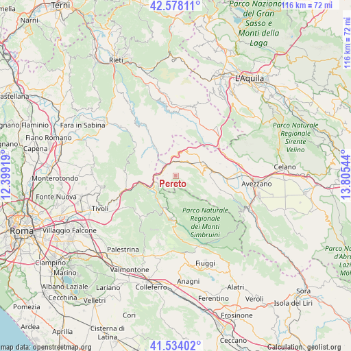
Pereto GPS coordinates[2]
42° 3' 29.556" North, 13° 6' 8.316" East
| Map corner | latitude | longitude |
|---|---|---|
| Upper-left | 42.57811°, | 12.39919° |
| Center: | 42.05821°, | 13.10231° |
| Lower-right: | 41.53402°, | 13.80544° |
| Map W x H: | 116.1×116.1 km | = 72.1×72.1mi |
| max Lat: | 47.04031° ⇑69.8% North |
| Pereto: | 42.05821° |
| min Lat: | ⇓30.2% South 35.50142° |
| min Long | Pereto | max Long |
| 6.69888° | 13.10231° | 18.48682° |
| W 69.5%⇐ | ⇒30.5% E |
Elevation
Elevation of Pereto is 817 m = 2680 ft, and this is 510.3 m = 1674 ft above average elevation for this country.
| Max E: |
2085 m = 6841 ft | 6.5% |
| Pereto | 817 m 2680 ft | |
| Avg. | 306.7 m = 1006 ft | |
Min E: |
-4 m = -13 ft | 93.5% |
See also: Italy elevation on elevation.city.
Geographical zone
Pereto is located in North temperate zone (between Tropic of Cancer and the Arctic Circle). Distance of this Northern Tropic circle is 2070.5 km =1286.5 mi to South.| Distance of | km | miles | from Pereto |
|---|---|---|---|
| North Pole | 5330.6 | 3312.3 | to North |
| Arctic Circle | 2724.7 | 1693 | to North |
| Tropic Cancer | 2070.5 | 1286.5 | to South |
| Equator | 4676.4 | 2905.8 | to South |


Nearby cities:
15 places around Pereto: (largest is in red/bold)
• Agosta
10.2 km =6.3 mi,  213°
213°
• Anticoli Corrado
10.8 km =6.7 mi,  238°
238°
• Arsoli
7.4 km =4.6 mi,  255°
255°
• Camerata Nuova
4.5 km =2.8 mi,  172°
172°
• Carsoli
4.7 km =2.9 mi,  345°
345°
• Cervara di Roma
8.3 km =5.2 mi,  200°
200°
• Collalto Sabino
9.6 km =6 mi,  332°
332°
• Marano Equo
10 km =6.2 mi,  225°
225°
• Oricola
5.3 km =3.3 mi, 259°
• Riofreddo
8.7 km =5.4 mi,  270°
270°
• Rocca di Botte
3.9 km =2.4 mi,  219°
219°
• Roviano
9.6 km =6 mi,  248°
248°
• Sante Marie
9.6 km =6 mi,  58°
58°
• Vallinfreda
9.3 km =5.8 mi,  288°
288°
• Vivaro Romano
9.3 km =5.8 mi,  300°
300°
Sources, notices
• [Note1] Compared only with cities in Italy existing in our database
• [Src1] Map data: © OpenStreetMap contributors (CC-BY-SA)
• [Src2] Other city data from geonames.org with taken over terms of usage.
• [Src3] Geographical zone / Annual Mean Temperature by Robert A. Rohde @ Wikipedia
