Ceregnano geodata
Ceregnano (Veneto) is a seat of a third-order administrative division; located in Italy in Europe/Rome (GMT+2) time zone. With population of 1,253 people, there are 5776 cities with bigger population in this country. Compared to other cities in Italy, 61.1% of cities are located further ↓South; 54.1% of cities are located further ←West and 99% of cities have higher elevation than Ceregnano. Note1


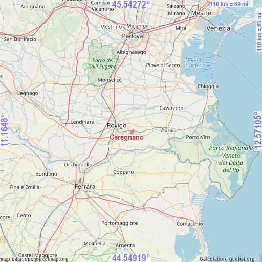
Ceregnano GPS coordinates[2]
45° 2' 53.196" North, 11° 52' 4.512" East
| Map corner | latitude | longitude |
|---|---|---|
| Upper-left | 45.54272°, | 11.1648° |
| Center: | 45.04811°, | 11.86792° |
| Lower-right: | 44.54919°, | 12.57105° |
| Map W x H: | 110.5×110.5 km | = 68.7×68.7mi |
| max Lat: | 47.04031° ⇑38.9% North |
| Ceregnano: | 45.04811° |
| min Lat: | ⇓61.1% South 35.50142° |
| min Long | Ceregnano | max Long |
| 6.69888° | 11.86792° | 18.48682° |
| W 54.1%⇐ | ⇒45.9% E |
Elevation
Elevation of Ceregnano is 2 m = 7 ft, and this is 304.7 m = 1000 ft below average elevation for this country.
| Max E: |
2085 m = 6841 ft | 99% |
| Avg. | 306.7 m = 1006 ft | |
| Ceregnano | 2 m = 7 ft | |
Min E: |
-4 m = -13 ft | 1% |
See also: Italy elevation on elevation.city.
Geographical zone
Ceregnano is located in North temperate zone (between Tropic of Cancer and the Arctic Circle). Distance of this North polar circle is 2392.3 km =1486.5 mi to North.| Distance of | km | miles | from Ceregnano |
|---|---|---|---|
| North Pole | 4998.2 | 3105.7 | to North |
| Arctic Circle | 2392.3 | 1486.5 | to North |
| Tropic Cancer | 2403 | 1493.2 | to South |
| Equator | 5008.9 | 3112.4 | to South |


Nearby cities:
15 places around Ceregnano: (largest is in red/bold)
• Alberone
9.8 km =6.1 mi,  198°
198°
• Boara Pisani
9.4 km =5.8 mi,  314°
314°
• Buso
2.5 km =1.6 mi,  319°
319°
• Cologna
9.1 km =5.7 mi,  166°
166°
• Crespino
7.2 km =4.5 mi, 166°
• Gavello
4.4 km =2.7 mi,  125°
125°
• Grignano Polesine
9.5 km =5.9 mi,  266°
266°
• Guarda Veneta
9 km =5.6 mi,  215°
215°
• Lama Pezzoli
3.3 km =2.1 mi,  98°
98°
• Mardimago
7 km =4.3 mi,  339°
339°
• Pontecchio Polesine
5.3 km =3.3 mi,  234°
234°
• Rovigo
6.6 km =4.1 mi,  291°
291°
• San Martino di Venezze
8.6 km =5.3 mi,  1°
1°
• Sant'Apollinare
3.4 km =2.1 mi,  256°
256°
• Villadose
3.6 km =2.2 mi,  42°
42°
Sources, notices
• [Note1] Compared only with cities in Italy existing in our database
• [Src1] Map data: © OpenStreetMap contributors (CC-BY-SA)
• [Src2] Other city data from geonames.org with taken over terms of usage.
• [Src3] Geographical zone / Annual Mean Temperature by Robert A. Rohde @ Wikipedia
