Cerchio geodata
Cerchio (Abruzzo) is a seat of a third-order administrative division; located in Italy in Europe/Rome (GMT+2) time zone. With population of 1,621 people, there are 4845 cities with bigger population in this country. Compared to other cities in Italy, 69.8% of cities are located further ↑North; 74.6% of cities are located further ←West and 93% of cities have lower elevation than Cerchio. Note1


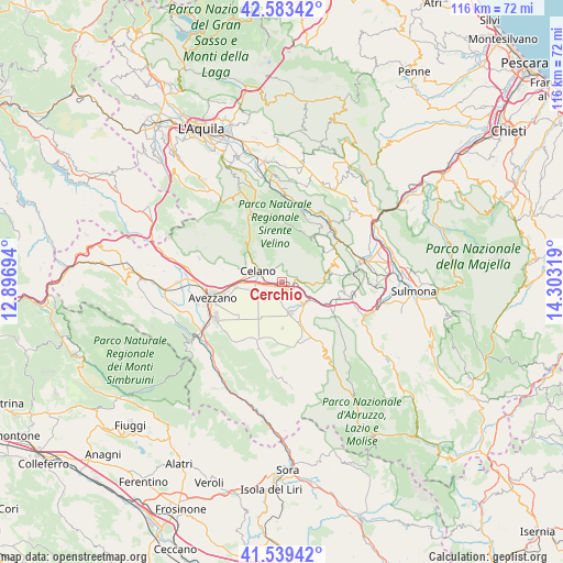
Cerchio GPS coordinates[2]
42° 3' 48.852" North, 13° 36' 0.216" East
| Map corner | latitude | longitude |
|---|---|---|
| Upper-left | 42.58342°, | 12.89694° |
| Center: | 42.06357°, | 13.60006° |
| Lower-right: | 41.53942°, | 14.30319° |
| Map W x H: | 116.1×116.1 km | = 72.1×72.1mi |
| max Lat: | 47.04031° ⇑69.8% North |
| Cerchio: | 42.06357° |
| min Lat: | ⇓30.2% South 35.50142° |
| min Long | Cerchio | max Long |
| 6.69888° | 13.60006° | 18.48682° |
| W 74.6%⇐ | ⇒25.4% E |
Elevation
Elevation of Cerchio is 802 m = 2631 ft, and this is 495.3 m = 1625 ft above average elevation for this country.
| Max E: |
2085 m = 6841 ft | 7% |
| Cerchio | 802 m 2631 ft | |
| Avg. | 306.7 m = 1006 ft | |
Min E: |
-4 m = -13 ft | 93% |
See also: Italy elevation on elevation.city.
Geographical zone
Cerchio is located in North temperate zone (between Tropic of Cancer and the Arctic Circle). Distance of this Northern Tropic circle is 2071.1 km =1286.9 mi to South.| Distance of | km | miles | from Cerchio |
|---|---|---|---|
| North Pole | 5330 | 3311.9 | to North |
| Arctic Circle | 2724.1 | 1692.7 | to North |
| Tropic Cancer | 2071.1 | 1286.9 | to South |
| Equator | 4677 | 2906.2 | to South |


Nearby cities:
15 places around Cerchio: (largest is in red/bold)
• Aielli
2.1 km =1.3 mi,  339°
339°
• Aielli Stazione
1.3 km =0.8 mi,  271°
271°
• Castel di Ieri
13 km =8.1 mi,  64°
64°
• Castelvecchio Subequo
12.9 km =8 mi, 55°
• Celano
7.1 km =4.4 mi,  285°
285°
• Collarmele
2.2 km =1.4 mi,  99°
99°
• Gagliano Aterno
10.8 km =6.7 mi,  49°
49°
• Ortona dei Marsi
12.9 km =8 mi,  124°
124°
• Ortucchio
12.6 km =7.8 mi,  162°
162°
• Ovindoli
10.8 km =6.7 mi,  319°
319°
• Pescina
6.1 km =3.8 mi,  136°
136°
• San Benedetto dei Marsi
6.5 km =4 mi, 162°
• Secinaro
11.8 km =7.3 mi,  34°
34°
• Trasacco
13 km =8.1 mi,  205°
205°
• Venere
8.9 km =5.5 mi, 155°
Sources, notices
• [Note1] Compared only with cities in Italy existing in our database
• [Src1] Map data: © OpenStreetMap contributors (CC-BY-SA)
• [Src2] Other city data from geonames.org with taken over terms of usage.
• [Src3] Geographical zone / Annual Mean Temperature by Robert A. Rohde @ Wikipedia
