Celano geodata
Celano (Abruzzo) is a seat of a third-order administrative division; located in Italy in Europe/Rome (GMT+2) time zone. With population of 9,966 people, there are 954 cities with bigger population in this country. Compared to other cities in Italy, 69.6% of cities are located further ↑North; 73.8% of cities are located further ←West and 90.9% of cities have lower elevation than Celano. Note1


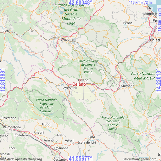
Celano GPS coordinates[2]
42° 4' 50.772" North, 13° 31' 1.2" East
| Map corner | latitude | longitude |
|---|---|---|
| Upper-left | 42.60048°, | 12.81388° |
| Center: | 42.08077°, | 13.517° |
| Lower-right: | 41.55677°, | 14.22013° |
| Map W x H: | 116×116 km | = 72.1×72.1mi |
| max Lat: | 47.04031° ⇑69.6% North |
| Celano: | 42.08077° |
| min Lat: | ⇓30.4% South 35.50142° |
| min Long | Celano | max Long |
| 6.69888° | 13.517° | 18.48682° |
| W 73.8%⇐ | ⇒26.2% E |
Elevation
Elevation of Celano is 742 m = 2434 ft, and this is 435.3 m = 1428 ft above average elevation for this country.
| Max E: |
2085 m = 6841 ft | 9.1% |
| Celano | 742 m 2434 ft | |
| Avg. | 306.7 m = 1006 ft | |
Min E: |
-4 m = -13 ft | 90.9% |
See also: Italy elevation on elevation.city.
Geographical zone
Celano is located in North temperate zone (between Tropic of Cancer and the Arctic Circle). Distance of this Northern Tropic circle is 2073 km =1288.1 mi to South.| Distance of | km | miles | from Celano |
|---|---|---|---|
| North Pole | 5328.1 | 3310.7 | to North |
| Arctic Circle | 2722.2 | 1691.5 | to North |
| Tropic Cancer | 2073 | 1288.1 | to South |
| Equator | 4678.9 | 2907.3 | to South |


Nearby cities:
15 places around Celano: (largest is in red/bold)
• Aielli
6.1 km =3.8 mi,  89°
89°
• Aielli Stazione
5.9 km =3.7 mi,  108°
108°
• Antrosano
9 km =5.6 mi,  258°
258°
• Avezzano
9.4 km =5.8 mi,  232°
232°
• Cappelle
11.4 km =7.1 mi, 262°
• Cerchio
7.1 km =4.4 mi, 105°
• Cese
12.3 km =7.6 mi,  239°
239°
• Collarmele
9.3 km =5.8 mi,  104°
104°
• Magliano De'Marsi
12.7 km =7.9 mi,  275°
275°
• Massa d'Albe-Corona
10.5 km =6.5 mi,  286°
286°
• Ovindoli
6.3 km =3.9 mi,  359°
359°
• Pescina
12.8 km =8 mi,  119°
119°
• Rocca di Mezzo
13.7 km =8.5 mi,  0°
0°
• San Benedetto dei Marsi
12 km =7.5 mi,  132°
132°
• Trasacco
13.8 km =8.6 mi,  174°
174°
Sources, notices
• [Note1] Compared only with cities in Italy existing in our database
• [Src1] Map data: © OpenStreetMap contributors (CC-BY-SA)
• [Src2] Other city data from geonames.org with taken over terms of usage.
• [Src3] Geographical zone / Annual Mean Temperature by Robert A. Rohde @ Wikipedia
