Trasacco geodata
Trasacco (Abruzzo) is a seat of a third-order administrative division; located in Italy in Europe/Rome (GMT+2) time zone. With population of 6,144 people, there are 1605 cities with bigger population in this country. Compared to other cities in Italy, 70.7% of cities are located further ↑North; 74% of cities are located further ←West and 88.7% of cities have lower elevation than Trasacco. Note1


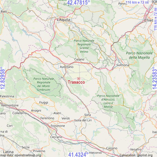
Trasacco GPS coordinates[2]
41° 57' 26.712" North, 13° 31' 57.72" East
| Map corner | latitude | longitude |
|---|---|---|
| Upper-left | 42.47815°, | 12.82958° |
| Center: | 41.95742°, | 13.5327° |
| Lower-right: | 41.4324°, | 14.23583° |
| Map W x H: | 116.3×116.3 km | = 72.3×72.3mi |
| max Lat: | 47.04031° ⇑70.7% North |
| Trasacco: | 41.95742° |
| min Lat: | ⇓29.3% South 35.50142° |
| min Long | Trasacco | max Long |
| 6.69888° | 13.5327° | 18.48682° |
| W 74%⇐ | ⇒26% E |
Elevation
Elevation of Trasacco is 688 m = 2257 ft, and this is 381.3 m = 1251 ft above average elevation for this country.
| Max E: |
2085 m = 6841 ft | 11.3% |
| Trasacco | 688 m 2257 ft | |
| Avg. | 306.7 m = 1006 ft | |
Min E: |
-4 m = -13 ft | 88.7% |
See also: Italy elevation on elevation.city.
Geographical zone
Trasacco is located in North temperate zone (between Tropic of Cancer and the Arctic Circle). Distance of this Northern Tropic circle is 2059.3 km =1279.6 mi to South.| Distance of | km | miles | from Trasacco |
|---|---|---|---|
| North Pole | 5341.8 | 3319.2 | to North |
| Arctic Circle | 2735.9 | 1700 | to North |
| Tropic Cancer | 2059.3 | 1279.6 | to South |
| Equator | 4665.2 | 2898.8 | to South |


Nearby cities:
15 places around Trasacco: (largest is in red/bold)
• Aielli Stazione
12.6 km =7.8 mi,  19°
19°
• Avezzano
11.9 km =7.4 mi,  312°
312°
• Canistro Inferiore
10.2 km =6.3 mi,  259°
259°
• Capistrello
11.4 km =7.1 mi,  278°
278°
• Civita d'Antino
9.4 km =5.8 mi,  212°
212°
• Civitella Roveto
10.2 km =6.3 mi,  241°
241°
• Collelongo
8.9 km =5.5 mi,  151°
151°
• Luco dei Marsi
4.9 km =3 mi,  272°
272°
• Morino
12.1 km =7.5 mi, 211°
• Ortucchio
9.4 km =5.8 mi,  91°
91°
• Pescina
12.2 km =7.6 mi,  53°
53°
• San Benedetto dei Marsi
9.4 km =5.8 mi, 53°
• San Vincenzo Valle Roveto
12.6 km =7.8 mi,  178°
178°
• Venere
10 km =6.2 mi,  68°
68°
• Villavallelonga
12.1 km =7.5 mi,  142°
142°
Sources, notices
• [Note1] Compared only with cities in Italy existing in our database
• [Src1] Map data: © OpenStreetMap contributors (CC-BY-SA)
• [Src2] Other city data from geonames.org with taken over terms of usage.
• [Src3] Geographical zone / Annual Mean Temperature by Robert A. Rohde @ Wikipedia
