Cerano geodata
Cerano (Piedmont) is a seat of a third-order administrative division; located in Italy in Europe/Rome (GMT+2) time zone. With population of 6,499 people, there are 1501 cities with bigger population in this country. Compared to other cities in Italy, 70.5% of cities are located further ↓South; 84.3% of cities are located further →East and 64.9% of cities have higher elevation than Cerano. Note1


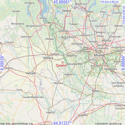
Cerano GPS coordinates[2]
45° 24' 32.94" North, 8° 47' 0.636" East
| Map corner | latitude | longitude |
|---|---|---|
| Upper-left | 45.90061°, | 8.08039° |
| Center: | 45.40915°, | 8.78351° |
| Lower-right: | 44.91337°, | 9.48664° |
| Map W x H: | 109.8×109.8 km | = 68.2×68.2mi |
| max Lat: | 47.04031° ⇑29.5% North |
| Cerano: | 45.40915° |
| min Lat: | ⇓70.5% South 35.50142° |
| min Long | Cerano | max Long |
| 6.69888° | 8.78351° | 18.48682° |
| W 15.7%⇐ | ⇒84.3% E |
Elevation
Elevation of Cerano is 128 m = 420 ft, and this is 178.7 m = 586 ft below average elevation for this country.
| Max E: |
2085 m = 6841 ft | 64.9% |
| Avg. | 306.7 m = 1006 ft | |
| Cerano | 128 m = 420 ft | |
Min E: |
-4 m = -13 ft | 35.1% |
See also: Italy elevation on elevation.city.
Geographical zone
Cerano is located in North temperate zone (between Tropic of Cancer and the Arctic Circle). Distance of this North polar circle is 2352.1 km =1461.5 mi to North.| Distance of | km | miles | from Cerano |
|---|---|---|---|
| North Pole | 4958 | 3080.8 | to North |
| Arctic Circle | 2352.1 | 1461.5 | to North |
| Tropic Cancer | 2443.1 | 1518.1 | to South |
| Equator | 5049 | 3137.3 | to South |


Nearby cities:
15 places around Cerano: (largest is in red/bold)
• Bernate Ticino
8.2 km =5.1 mi,  19°
19°
• Boffalora Sopra Ticino
7.5 km =4.7 mi,  29°
29°
• Casate
9.8 km =6.1 mi, 20°
• Cascinazza
8 km =5 mi,  83°
83°
• Cassinetta di Lugagnano
9.7 km =6 mi, 81°
• Cassolnovo
5.8 km =3.6 mi,  157°
157°
• Castellazzo de' Barzi
9.7 km =6 mi,  67°
67°
• Casterno
7.1 km =4.4 mi, 71°
• Gravellona
9.2 km =5.7 mi,  189°
189°
• Robecco sul Naviglio
8.5 km =5.3 mi, 69°
• Romentino
7.9 km =4.9 mi,  319°
319°
• Sozzago
4.9 km =3 mi,  255°
255°
• Terdobbiate
7.9 km =4.9 mi,  241°
241°
• Tornaco
7.8 km =4.8 mi,  221°
221°
• Trecate
4.6 km =2.9 mi,  306°
306°
Sources, notices
• [Note1] Compared only with cities in Italy existing in our database
• [Src1] Map data: © OpenStreetMap contributors (CC-BY-SA)
• [Src2] Other city data from geonames.org with taken over terms of usage.
• [Src3] Geographical zone / Annual Mean Temperature by Robert A. Rohde @ Wikipedia
