Gravellona geodata
Gravellona (Lombardy) is a seat of a third-order administrative division; located in Italy in Europe/Rome (GMT+2) time zone. With population of 2,415 people, there are 3624 cities with bigger population in this country. Compared to other cities in Italy, 68.2% of cities are located further ↓South; 84.6% of cities are located further →East and 67.1% of cities have higher elevation than Gravellona. Note1
Administrative division(s):
- Level 1: Lombardy
- Level 2: Provincia di Pavia
- Level 3: Gravellona Lomellina


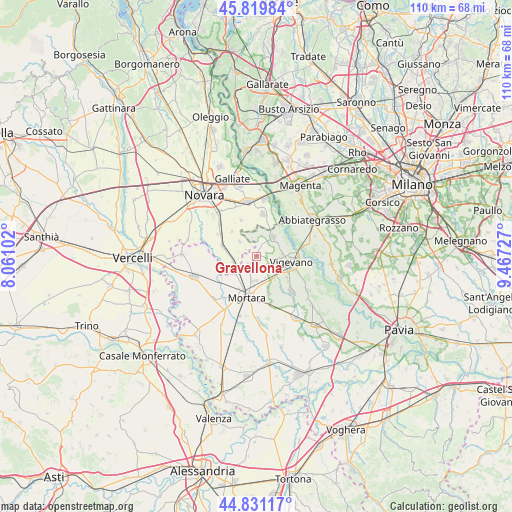
Gravellona GPS coordinates[2]
45° 19' 39.576" North, 8° 45' 50.904" East
| Map corner | latitude | longitude |
|---|---|---|
| Upper-left | 45.81984°, | 8.06102° |
| Center: | 45.32766°, | 8.76414° |
| Lower-right: | 44.83117°, | 9.46727° |
| Map W x H: | 109.9×109.9 km | = 68.3×68.3mi |
| max Lat: | 47.04031° ⇑31.8% North |
| Gravellona: | 45.32766° |
| min Lat: | ⇓68.2% South 35.50142° |
| min Long | Gravellona | max Long |
| 6.69888° | 8.76414° | 18.48682° |
| W 15.4%⇐ | ⇒84.6% E |
Elevation
Elevation of Gravellona is 115 m = 377 ft, and this is 191.7 m = 629 ft below average elevation for this country.
| Max E: |
2085 m = 6841 ft | 67.1% |
| Avg. | 306.7 m = 1006 ft | |
| Gravellona | 115 m = 377 ft | |
Min E: |
-4 m = -13 ft | 32.9% |
See also: Italy elevation on elevation.city.
Geographical zone
Gravellona is located in North temperate zone (between Tropic of Cancer and the Arctic Circle). Distance of this North polar circle is 2361.2 km =1467.2 mi to North.| Distance of | km | miles | from Gravellona |
|---|---|---|---|
| North Pole | 4967.1 | 3086.4 | to North |
| Arctic Circle | 2361.2 | 1467.2 | to North |
| Tropic Cancer | 2434 | 1512.4 | to South |
| Equator | 5040 | 3131.7 | to South |


Nearby cities:
15 places around Gravellona: (largest is in red/bold)
• Albonese
6 km =3.7 mi,  229°
229°
• Borgolavezzaro
5.2 km =3.2 mi,  259°
259°
• Cassolnovo
5.3 km =3.3 mi,  45°
45°
• Cerano
9.2 km =5.7 mi,  9°
9°
• Cilavegna
2.4 km =1.5 mi,  218°
218°
• Mortara
9 km =5.6 mi,  195°
195°
• Nibbiola
9.8 km =6.1 mi,  300°
300°
• Nicorvo
8.9 km =5.5 mi,  238°
238°
• Parona
5.2 km =3.2 mi,  191°
191°
• Remondò
10.3 km =6.4 mi,  162°
162°
• Sozzago
8.5 km =5.3 mi,  337°
337°
• Terdobbiate
7.6 km =4.7 mi,  314°
314°
• Tornaco
4.9 km =3 mi, 311°
• Vespolate
7.8 km =4.8 mi,  288°
288°
• Vigevano
7.2 km =4.5 mi,  102°
102°
Sources, notices
• [Note1] Compared only with cities in Italy existing in our database
• [Src1] Map data: © OpenStreetMap contributors (CC-BY-SA)
• [Src2] Other city data from geonames.org with taken over terms of usage.
• [Src3] Geographical zone / Annual Mean Temperature by Robert A. Rohde @ Wikipedia
