Celleno geodata
Celleno (Latium) is a seat of a third-order administrative division; located in Italy in Europe/Rome (GMT+2) time zone. With population of 932 people, there are 6974 cities with bigger population in this country. Compared to other cities in Italy, 65.9% of cities are located further ↑North; 57.7% of cities are located further ←West and 70.8% of cities have lower elevation than Celleno. Note1


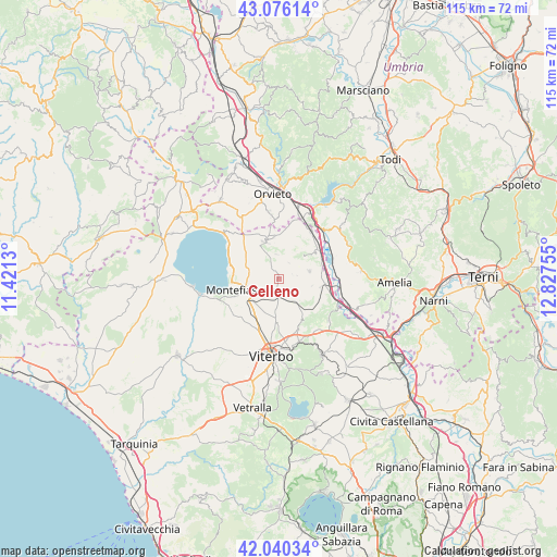
Celleno GPS coordinates[2]
42° 33' 37.404" North, 12° 7' 27.912" East
| Map corner | latitude | longitude |
|---|---|---|
| Upper-left | 43.07614°, | 11.4213° |
| Center: | 42.56039°, | 12.12442° |
| Lower-right: | 42.04034°, | 12.82755° |
| Map W x H: | 115.2×115.2 km | = 71.6×71.6mi |
| max Lat: | 47.04031° ⇑65.9% North |
| Celleno: | 42.56039° |
| min Lat: | ⇓34.1% South 35.50142° |
| min Long | Celleno | max Long |
| 6.69888° | 12.12442° | 18.48682° |
| W 57.7%⇐ | ⇒42.3% E |
Elevation
Elevation of Celleno is 402 m = 1319 ft, and this is 95.3 m = 313 ft above average elevation for this country.
| Max E: |
2085 m = 6841 ft | 29.2% |
| Celleno | 402 m 1319 ft | |
| Avg. | 306.7 m = 1006 ft | |
Min E: |
-4 m = -13 ft | 70.8% |
See also: Italy elevation on elevation.city.
Geographical zone
Celleno is located in North temperate zone (between Tropic of Cancer and the Arctic Circle). Distance of this Northern Tropic circle is 2126.4 km =1321.3 mi to South.| Distance of | km | miles | from Celleno |
|---|---|---|---|
| North Pole | 5274.8 | 3277.6 | to North |
| Arctic Circle | 2668.9 | 1658.4 | to North |
| Tropic Cancer | 2126.4 | 1321.3 | to South |
| Equator | 4732.3 | 2940.5 | to South |


Nearby cities:
15 places around Celleno: (largest is in red/bold)
• Bagnoregio
8.1 km =5 mi,  339°
339°
• Bomarzo
13.5 km =8.4 mi,  129°
129°
• Canale Nuovo
14.1 km =8.8 mi,  2°
2°
• Castiglione in Teverina
11.9 km =7.4 mi,  32°
32°
• Civitella d'Agliano
6.9 km =4.3 mi,  46°
46°
• Graffignano
6.5 km =4 mi,  75°
75°
• Grotte Santo Stefano
6.2 km =3.9 mi,  140°
140°
• Lubriano
8.5 km =5.3 mi,  351°
351°
• Montefiascone
7.8 km =4.8 mi,  255°
255°
• Pallone
13.4 km =8.3 mi,  162°
162°
• Paparano
12.1 km =7.5 mi,  166°
166°
• Porano
13.5 km =8.4 mi, 352°
• Sipicciano
8.7 km =5.4 mi,  101°
101°
• Vitorchiano
11.2 km =7 mi, 159°
• Zepponami
7 km =4.3 mi,  235°
235°
Sources, notices
• [Note1] Compared only with cities in Italy existing in our database
• [Src1] Map data: © OpenStreetMap contributors (CC-BY-SA)
• [Src2] Other city data from geonames.org with taken over terms of usage.
• [Src3] Geographical zone / Annual Mean Temperature by Robert A. Rohde @ Wikipedia
