Graffignano geodata
Graffignano (Latium) is a seat of a third-order administrative division; located in Italy in Europe/Rome (GMT+2) time zone. With population of 939 people, there are 6928 cities with bigger population in this country. Compared to other cities in Italy, 65.9% of cities are located further ↑North; 58.6% of cities are located further ←West and 55.9% of cities have higher elevation than Graffignano. Note1


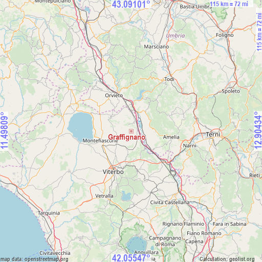
Graffignano GPS coordinates[2]
42° 34' 31.404" North, 12° 12' 4.356" East
| Map corner | latitude | longitude |
|---|---|---|
| Upper-left | 43.09101°, | 11.49809° |
| Center: | 42.57539°, | 12.20121° |
| Lower-right: | 42.05547°, | 12.90434° |
| Map W x H: | 115.1×115.1 km | = 71.5×71.5mi |
| max Lat: | 47.04031° ⇑65.9% North |
| Graffignano: | 42.57539° |
| min Lat: | ⇓34.1% South 35.50142° |
| min Long | Graffignano | max Long |
| 6.69888° | 12.20121° | 18.48682° |
| W 58.6%⇐ | ⇒41.4% E |
Elevation
Elevation of Graffignano is 196 m = 643 ft, and this is 110.7 m = 363 ft below average elevation for this country.
| Max E: |
2085 m = 6841 ft | 55.9% |
| Avg. | 306.7 m = 1006 ft | |
| Graffignano | 196 m = 643 ft | |
Min E: |
-4 m = -13 ft | 44.1% |
See also: Italy elevation on elevation.city.
Geographical zone
Graffignano is located in North temperate zone (between Tropic of Cancer and the Arctic Circle). Distance of this Northern Tropic circle is 2128 km =1322.3 mi to South.| Distance of | km | miles | from Graffignano |
|---|---|---|---|
| North Pole | 5273.1 | 3276.6 | to North |
| Arctic Circle | 2667.2 | 1657.3 | to North |
| Tropic Cancer | 2128 | 1322.3 | to South |
| Equator | 4733.9 | 2941.5 | to South |


Nearby cities:
15 places around Graffignano: (largest is in red/bold)
• Alviano
8.1 km =5 mi,  77°
77°
• Attigliano
10.2 km =6.3 mi,  131°
131°
• Bagnoregio
10.9 km =6.8 mi,  302°
302°
• Baschi
11 km =6.8 mi,  7°
7°
• Bomarzo
11.1 km =6.9 mi,  158°
158°
• Castiglione in Teverina
8.4 km =5.2 mi,  1°
1°
• Celleno
6.5 km =4 mi,  255°
255°
• Civitella d'Agliano
3.3 km =2.1 mi,  338°
338°
• Grotte Santo Stefano
6.9 km =4.3 mi,  200°
200°
• Guardea
9.7 km =6 mi,  56°
56°
• Lubriano
10.1 km =6.3 mi,  311°
311°
• Lugnano in Teverina
10.8 km =6.7 mi,  89°
89°
• Montecchio
12 km =7.5 mi,  36°
36°
• Sipicciano
4.1 km =2.5 mi,  147°
147°
• Vitorchiano
12.4 km =7.7 mi,  191°
191°
Sources, notices
• [Note1] Compared only with cities in Italy existing in our database
• [Src1] Map data: © OpenStreetMap contributors (CC-BY-SA)
• [Src2] Other city data from geonames.org with taken over terms of usage.
• [Src3] Geographical zone / Annual Mean Temperature by Robert A. Rohde @ Wikipedia
