Parco Scizzo-Parchitello geodata
Parco Scizzo-Parchitello (Apulia) is a populated place; located in Italy in Europe/Rome (GMT+2) time zone. With population of 3,705 people, there are 2553 cities with bigger population in this country. Compared to other cities in Italy, 77.7% of cities are located further ↑North; 98% of cities are located further ←West and 82.7% of cities have higher elevation than Parco Scizzo-Parchitello. Note1
Current local time in Parco Scizzo-Parchitello:
02:13 AM, WednesdayDifference from your time zone: hours


Parco Scizzo-Parchitello GPS coordinates[2]
41° 4' 28.452" North, 16° 59' 35.844" East
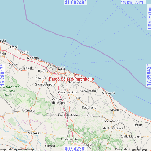
| Map corner | latitude | longitude |
|---|---|---|
| Upper-left | 41.60249°, | 16.29017° |
| Center: | 41.07457°, | 16.99329° |
| Lower-right: | 40.54238°, | 17.69642° |
| Map W x H: | 117.9×117.9 km | = 73.3×73.3mi |
| max Lat: | 47.04031° ⇑77.7% North |
| Parco Scizzo-Parchitello: | 41.07457° |
| min Lat: | ⇓22.3% South 35.50142° |
| min Long | Parco Scizzo-Pa | max Long |
| 6.69888° | 16.99329° | 18.48682° |
| W 98%⇐ | ⇒2% E |
Elevation
Elevation of Parco Scizzo-Parchitello is 39 m = 128 ft, and this is 267.7 m = 878 ft below average elevation for this country.
| Max E: |
2085 m = 6841 ft | 82.7% |
| Avg. | 306.7 m = 1006 ft | |
| Parco Scizzo-Parchitello | 39 m = 128 ft | |
Min E: |
-4 m = -13 ft | 17.3% |
See also: Italy elevation on elevation.city.
Geographical zone
Parco Scizzo-Parchitello is located in North temperate zone (between Tropic of Cancer and the Arctic Circle). Distance of this Northern Tropic circle is 1961.1 km =1218.6 mi to South.| Distance of | km | miles | from Parco Scizzo-Parchitello |
|---|---|---|---|
| North Pole | 5440 | 3380.3 | to North |
| Arctic Circle | 2834.1 | 1761 | to North |
| Tropic Cancer | 1961.1 | 1218.6 | to South |
| Equator | 4567.1 | 2837.9 | to South |


Nearby cities:
15 places around Parco Scizzo-Parchitello: (largest is in red/bold)
• Adelfia
12.9 km =8 mi,  232°
232°
• Bari
11.5 km =7.1 mi,  296°
296°
• Bitritto
14.4 km =8.9 mi,  256°
256°
• Capurso
6.8 km =4.2 mi,  242°
242°
• Cellamare
8.2 km =5.1 mi,  222°
222°
• Lamie
10.9 km =6.8 mi,  245°
245°
• Loseto
12.6 km =7.8 mi, 253°
• Mola di Bari
8.3 km =5.2 mi,  101°
101°
• Noicattaro
4.5 km =2.8 mi,  183°
183°
• Parco Principi
12.7 km =7.9 mi,  214°
214°
• Rutigliano
7.3 km =4.5 mi,  171°
171°
• San Pietro
6.5 km =4 mi, 255°
• Superga
5.5 km =3.4 mi, 250°
• Triggiano
5.8 km =3.6 mi, 259°
• Valenzano
9.7 km =6 mi, 249°
Sources, notices
• [Note1] Compared only with cities in Italy existing in our database
• [Src1] Map data: © OpenStreetMap contributors (CC-BY-SA)
• [Src2] Other city data from geonames.org with taken over terms of usage.
• [Src3] Geographical zone / Annual Mean Temperature by Robert A. Rohde @ Wikipedia
