Castilenti geodata
Castilenti (Abruzzo) is a seat of a third-order administrative division; located in Italy in Europe/Rome (GMT+2) time zone. With population of 456 people, there are 10067 cities with bigger population in this country. Compared to other cities in Italy, 66.1% of cities are located further ↑North; 77.6% of cities are located further ←West and 55.1% of cities have lower elevation than Castilenti. Note1


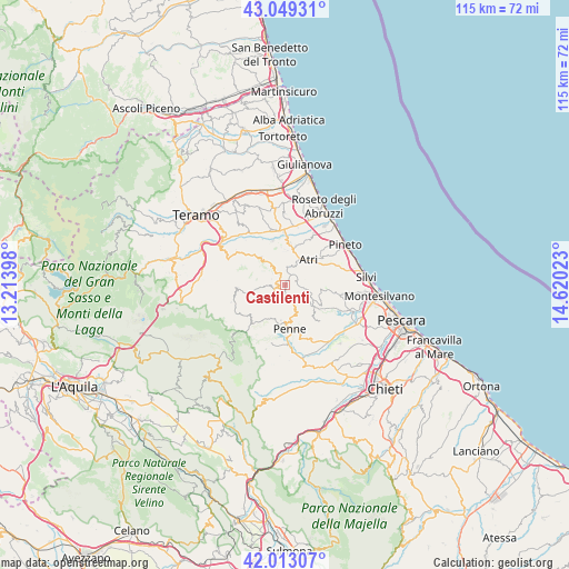
Castilenti GPS coordinates[2]
42° 32' 0.024" North, 13° 55' 1.56" East
| Map corner | latitude | longitude |
|---|---|---|
| Upper-left | 43.04931°, | 13.21398° |
| Center: | 42.53334°, | 13.9171° |
| Lower-right: | 42.01307°, | 14.62023° |
| Map W x H: | 115.2×115.2 km | = 71.6×71.6mi |
| max Lat: | 47.04031° ⇑66.1% North |
| Castilenti: | 42.53334° |
| min Lat: | ⇓33.9% South 35.50142° |
| min Long | Castilenti | max Long |
| 6.69888° | 13.9171° | 18.48682° |
| W 77.6%⇐ | ⇒22.4% E |
Elevation
Elevation of Castilenti is 266 m = 873 ft, and this is 40.7 m = 134 ft below average elevation for this country.
| Max E: |
2085 m = 6841 ft | 44.9% |
| Avg. | 306.7 m = 1006 ft | |
| Castilenti | 266 m = 873 ft | |
Min E: |
-4 m = -13 ft | 55.1% |
See also: Italy elevation on elevation.city.
Geographical zone
Castilenti is located in North temperate zone (between Tropic of Cancer and the Arctic Circle). Distance of this Northern Tropic circle is 2123.3 km =1319.4 mi to South.| Distance of | km | miles | from Castilenti |
|---|---|---|---|
| North Pole | 5277.8 | 3279.5 | to North |
| Arctic Circle | 2671.9 | 1660.2 | to North |
| Tropic Cancer | 2123.3 | 1319.4 | to South |
| Equator | 4729.3 | 2938.6 | to South |


Nearby cities:
15 places around Castilenti: (largest is in red/bold)
• Arsita
11.3 km =7 mi,  252°
252°
• Atri
7.6 km =4.7 mi,  50°
50°
• Bisenti
9.6 km =6 mi,  267°
267°
• Casoli
10.6 km =6.6 mi,  28°
28°
• Castiglione Messer Raimondo
3.1 km =1.9 mi, 267°
• Cellino Attanasio
7.4 km =4.6 mi,  321°
321°
• Cermignano
11.9 km =7.4 mi,  302°
302°
• Collecorvino
11.5 km =7.1 mi,  135°
135°
• Elice
4.5 km =2.8 mi,  104°
104°
• Fontanelle
9.4 km =5.8 mi,  4°
4°
• Montefino
3 km =1.9 mi, 297°
• Mutignano
11.4 km =7.1 mi,  57°
57°
• Penne
8.8 km =5.5 mi,  174°
174°
• Pianura Vomano
10.8 km =6.7 mi,  359°
359°
• Picciano
8.8 km =5.5 mi, 137°
Sources, notices
• [Note1] Compared only with cities in Italy existing in our database
• [Src1] Map data: © OpenStreetMap contributors (CC-BY-SA)
• [Src2] Other city data from geonames.org with taken over terms of usage.
• [Src3] Geographical zone / Annual Mean Temperature by Robert A. Rohde @ Wikipedia
